Navarrete geodata
Navarrete (Nayarit) is a populated place; located in Mexico in America/Mazatlan (GMT-7) time zone. With population of 1,603 people, there are 5394 cities with bigger population in this country. Compared to other cities in Mexico, 82.1% of cities are located further ↓South; 92.1% of cities are located further →East and 81.8% of cities have higher elevation than Navarrete. Note1


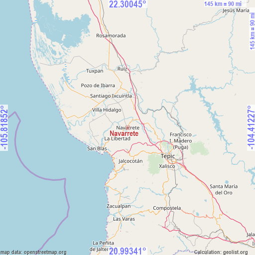
Navarrete GPS coordinates[2]
21° 38' 54.276" North, 105° 6' 55.404" West
| Map corner | latitude | longitude |
|---|---|---|
| Upper-left | 22.30045°, | -105.81852° |
| Center: | 21.64841°, | -105.11539° |
| Lower-right: | 20.99341°, | -104.41227° |
| Map W x H: | 145.3×145.3 km | = 90.3×90.3mi |
| max Lat: | 32.7° ⇑17.9% North |
| Navarrete: | 21.64841° |
| min Lat: | ⇓82.1% South 14.53588° |
| min Long | Navarrete | max Long |
| -117.105° | -105.11539° | -86.73105° |
| W 7.9%⇐ | ⇒92.1% E |
Elevation
Elevation of Navarrete is 72 m = 236 ft, and this is 1181.7 m = 3877 ft below average elevation for this country.
| Max E: |
3497 m = 11473 ft | 81.8% |
| Avg. | 1253.7 m = 4113 ft | |
| Navarrete | 72 m = 236 ft | |
Min E: |
-1 m = -3 ft | 18.2% |
See also: Mexico elevation on elevation.city.
Geographical zone
Navarrete is located in North Torrid zone (between Equator and Tropic of Cancer). Distance of this Northern Tropic circle is 198.8 km =123.5 mi to North.| Distance of | km | miles | from Navarrete |
|---|---|---|---|
| North Pole | 7600 | 4722.4 | to North |
| Arctic Circle | 4994.1 | 3103.2 | to North |
| Tropic Cancer | 198.8 | 123.5 | to North |
| Equator | 2407.1 | 1495.7 | to South |


Nearby cities:
15 places around Navarrete: (largest is in red/bold)
• Cinco de Mayo
5.5 km =3.4 mi,  31°
31°
• El Corte
15.6 km =9.7 mi,  300°
300°
• El Jicote
10.4 km =6.5 mi, 34°
• El Tambor
13.8 km =8.6 mi,  37°
37°
• El Trapichillo
16.1 km =10 mi,  121°
121°
• Huaristemba
4.5 km =2.8 mi,  286°
286°
• La Libertad
8.6 km =5.3 mi,  224°
224°
• La Yerba
15.6 km =9.7 mi,  154°
154°
• Leandro B. Flores
15.3 km =9.5 mi,  337°
337°
• Mecatán
12.5 km =7.8 mi,  181°
181°
• Mojarritas
13 km =8.1 mi, 26°
• Reforma Agraria
8.5 km =5.3 mi,  280°
280°
• Sauta
8.6 km =5.3 mi, 340°
• Vado del Cora (Estación Pani)
15 km =9.3 mi,  48°
48°
• Villa Hidalgo
15.8 km =9.8 mi,  311°
311°
Sources, notices
• [Note1] Compared only with cities in Mexico existing in our database
• [Src1] Map data: © OpenStreetMap contributors (CC-BY-SA)
• [Src2] Other city data from geonames.org with taken over terms of usage.
• [Src3] Geographical zone / Annual Mean Temperature by Robert A. Rohde @ Wikipedia
