Veintiocho de Agosto geodata
Veintiocho de Agosto (Coahuila) is a populated place; located in Mexico in America/Monterrey (GMT-6) time zone. With population of 591 people, there are 14530 cities with bigger population in this country. Compared to other cities in Mexico, 93.3% of cities are located further ↓South; 81.6% of cities are located further →East and 55.2% of cities have higher elevation than Veintiocho de Agosto. Note1


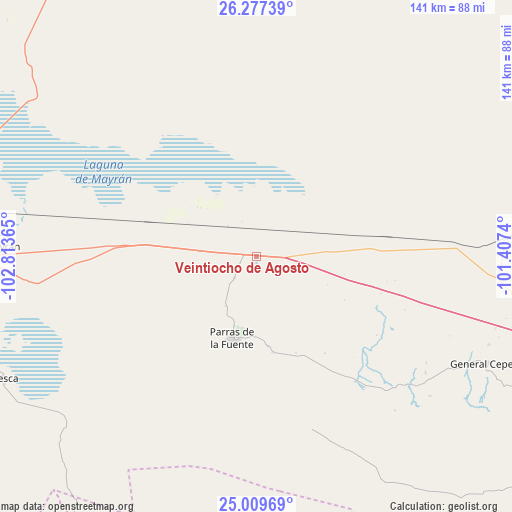
Veintiocho de Agosto GPS coordinates[2]
25° 38' 42.792" North, 102° 6' 37.872" West
| Map corner | latitude | longitude |
|---|---|---|
| Upper-left | 26.27739°, | -102.81365° |
| Center: | 25.64522°, | -102.11052° |
| Lower-right: | 25.00969°, | -101.4074° |
| Map W x H: | 141×141 km | = 87.6×87.6mi |
| max Lat: | 32.7° ⇑6.7% North |
| Veintiocho de Agosto: | 25.64522° |
| min Lat: | ⇓93.3% South 14.53588° |
| min Long | Veintiocho de A | max Long |
| -117.105° | -102.11052° | -86.73105° |
| W 18.4%⇐ | ⇒81.6% E |
Elevation
Elevation of Veintiocho de Agosto is 1191 m = 3907 ft, and this is 62.7 m = 206 ft below average elevation for this country.
| Max E: |
3497 m = 11473 ft | 55.2% |
| Avg. | 1253.7 m = 4113 ft | |
| Veintiocho de Agosto | 1191 m = 3907 ft | |
Min E: |
-1 m = -3 ft | 44.8% |
See also: Mexico elevation on elevation.city.
Geographical zone
Veintiocho de Agosto is located in North temperate zone (between Tropic of Cancer and the Arctic Circle). Distance of this Northern Tropic circle is 245.6 km =152.6 mi to South.| Distance of | km | miles | from Veintiocho de Agosto |
|---|---|---|---|
| North Pole | 7155.6 | 4446.3 | to North |
| Arctic Circle | 4549.7 | 2827.1 | to North |
| Tropic Cancer | 245.6 | 152.6 | to South |
| Equator | 2851.5 | 1771.8 | to South |


Nearby cities:
15 places around Veintiocho de Agosto: (largest is in red/bold)
• Ejido Emiliano Zapata
85.4 km =53.1 mi,  258°
258°
• Ejido Venustiano Carranza
91 km =56.5 mi,  248°
248°
• El Nilo
84 km =52.2 mi,  276°
276°
• General Cepeda
70.3 km =43.7 mi,  115°
115°
• Ignacio Zaragoza
86.9 km =54 mi,  274°
274°
• Mayran
73.5 km =45.7 mi, 272°
• Parras de la Fuente
23.6 km =14.7 mi,  196°
196°
• San Esteban de Abajo
89.5 km =55.6 mi, 274°
• San Felipe
86.8 km =53.9 mi, 272°
• San Francisco del Progreso
8.5 km =5.3 mi,  225°
225°
• San Marcos
90.1 km =56 mi, 271°
• San Miguel
84.4 km =52.4 mi, 274°
• San Pedro
88.4 km =54.9 mi, 278°
• San Rafael de Abajo
90.1 km =56 mi, 271°
• Viesca
77.6 km =48.2 mi,  243°
243°
Sources, notices
• [Note1] Compared only with cities in Mexico existing in our database
• [Src1] Map data: © OpenStreetMap contributors (CC-BY-SA)
• [Src2] Other city data from geonames.org with taken over terms of usage.
• [Src3] Geographical zone / Annual Mean Temperature by Robert A. Rohde @ Wikipedia
