Cuerámaro geodata
Cuerámaro (Guanajuato) is a seat of a second-order administrative division; located in Mexico in America/Mexico_City (GMT-6) time zone. With population of 13,948 people, there are 696 cities with bigger population in this country. Compared to other cities in Mexico, 70.5% of cities are located further ↓South; 78.8% of cities are located further →East and 60.1% of cities have lower elevation than Cuerámaro. Note1


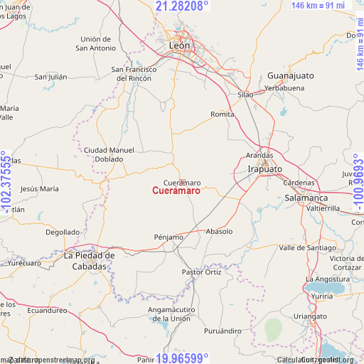
Cuerámaro GPS coordinates[2]
20° 37' 31.656" North, 101° 40' 20.712" West
| Map corner | latitude | longitude |
|---|---|---|
| Upper-left | 21.28208°, | -102.37555° |
| Center: | 20.62546°, | -101.67242° |
| Lower-right: | 19.96599°, | -100.9693° |
| Map W x H: | 146.3×146.3 km | = 90.9×90.9mi |
| max Lat: | 32.7° ⇑29.5% North |
| Cuerámaro: | 20.62546° |
| min Lat: | ⇓70.5% South 14.53588° |
| min Long | Cuerámaro | max Long |
| -117.105° | -101.67242° | -86.73105° |
| W 21.2%⇐ | ⇒78.8% E |
Elevation
Elevation of Cuerámaro is 1727 m = 5666 ft, and this is 473.3 m = 1553 ft above average elevation for this country.
| Max E: |
3497 m = 11473 ft | 39.9% |
| Cuerámaro | 1727 m 5666 ft | |
| Avg. | 1253.7 m = 4113 ft | |
Min E: |
-1 m = -3 ft | 60.1% |
See also: Mexico elevation on elevation.city.
Geographical zone
Cuerámaro is located in North Torrid zone (between Equator and Tropic of Cancer). Distance of this Northern Tropic circle is 312.6 km =194.2 mi to North.| Distance of | km | miles | from Cuerámaro |
|---|---|---|---|
| North Pole | 7713.7 | 4793.1 | to North |
| Arctic Circle | 5107.8 | 3173.8 | to North |
| Tropic Cancer | 312.6 | 194.2 | to North |
| Equator | 2293.3 | 1425 | to South |


Nearby cities:
15 places around Cuerámaro: (largest is in red/bold)
• Cerrito de Agua Caliente
9.2 km =5.7 mi,  82°
82°
• Chamacua
12.2 km =7.6 mi,  63°
63°
• El Platanar
3.4 km =2.1 mi,  239°
239°
• El Saucillo
8.7 km =5.4 mi,  333°
333°
• Galera de la Grulla
4.2 km =2.6 mi,  73°
73°
• La Carroza
10.6 km =6.6 mi,  128°
128°
• Loma de la Esperanza
12.6 km =7.8 mi, 72°
• Puerta de la Reserva
3.1 km =1.9 mi,  310°
310°
• Puerto de la Cruz
12.3 km =7.6 mi,  46°
46°
• San Antonio Cerro Prieto
11.5 km =7.1 mi,  12°
12°
• San Francisco de Horta (El Alacrán)
13.5 km =8.4 mi,  113°
113°
• San Gregorio
9.9 km =6.2 mi,  152°
152°
• San Juan de la Puerta
12.5 km =7.8 mi,  339°
339°
• San Rafael de Horta
13.5 km =8.4 mi,  89°
89°
• Tupataro
4.3 km =2.7 mi,  141°
141°
Sources, notices
• [Note1] Compared only with cities in Mexico existing in our database
• [Src1] Map data: © OpenStreetMap contributors (CC-BY-SA)
• [Src2] Other city data from geonames.org with taken over terms of usage.
• [Src3] Geographical zone / Annual Mean Temperature by Robert A. Rohde @ Wikipedia
