El Platanar geodata
El Platanar (Guanajuato) is a populated place; located in Mexico in America/Mexico_City (GMT-6) time zone. With population of 693 people, there are 12564 cities with bigger population in this country. Compared to other cities in Mexico, 70.2% of cities are located further ↓South; 79% of cities are located further →East and 63.5% of cities have lower elevation than El Platanar. Note1


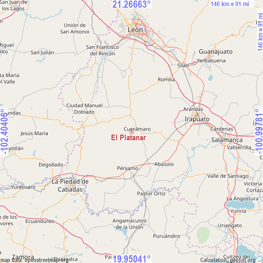
El Platanar GPS coordinates[2]
20° 36' 35.784" North, 101° 42' 3.348" West
| Map corner | latitude | longitude |
|---|---|---|
| Upper-left | 21.26663°, | -102.40406° |
| Center: | 20.60994°, | -101.70093° |
| Lower-right: | 19.95041°, | -100.99781° |
| Map W x H: | 146.3×146.4 km | = 90.9×91mi |
| max Lat: | 32.7° ⇑29.8% North |
| El Platanar: | 20.60994° |
| min Lat: | ⇓70.2% South 14.53588° |
| min Long | El Platanar | max Long |
| -117.105° | -101.70093° | -86.73105° |
| W 21%⇐ | ⇒79% E |
Elevation
Elevation of El Platanar is 1790 m = 5873 ft, and this is 536.3 m = 1760 ft above average elevation for this country.
| Max E: |
3497 m = 11473 ft | 36.5% |
| El Platanar | 1790 m 5873 ft | |
| Avg. | 1253.7 m = 4113 ft | |
Min E: |
-1 m = -3 ft | 63.5% |
See also: Mexico elevation on elevation.city.
Geographical zone
El Platanar is located in North Torrid zone (between Equator and Tropic of Cancer). Distance of this Northern Tropic circle is 314.3 km =195.3 mi to North.| Distance of | km | miles | from El Platanar |
|---|---|---|---|
| North Pole | 7715.5 | 4794.2 | to North |
| Arctic Circle | 5109.6 | 3175 | to North |
| Tropic Cancer | 314.3 | 195.3 | to North |
| Equator | 2291.6 | 1423.9 | to South |


Nearby cities:
15 places around El Platanar: (largest is in red/bold)
• Cerrito de Agua Caliente
12.4 km =7.7 mi,  76°
76°
• Chamacua
15.6 km =9.7 mi,  62°
62°
• Corralejo de Hidalgo
13.7 km =8.5 mi,  147°
147°
• Cuerámaro
3.4 km =2.1 mi, 59°
• El Saucillo
9.5 km =5.9 mi,  354°
354°
• El Tule
14.2 km =8.8 mi,  130°
130°
• Galera de la Grulla
7.6 km =4.7 mi,  67°
67°
• La Carroza
12.3 km =7.6 mi,  113°
113°
• Puerta de la Reserva
3.8 km =2.4 mi,  9°
9°
• Puerto de la Cruz
15.7 km =9.8 mi,  49°
49°
• San Antonio Cerro Prieto
14 km =8.7 mi,  22°
22°
• San Gregorio
10.3 km =6.4 mi, 132°
• San Juan de la Puerta
13.5 km =8.4 mi, 354°
• Tupataro
5.9 km =3.7 mi, 106°
• Zapote de Cestao
14.3 km =8.9 mi,  169°
169°
Sources, notices
• [Note1] Compared only with cities in Mexico existing in our database
• [Src1] Map data: © OpenStreetMap contributors (CC-BY-SA)
• [Src2] Other city data from geonames.org with taken over terms of usage.
• [Src3] Geographical zone / Annual Mean Temperature by Robert A. Rohde @ Wikipedia
