Costa Azul geodata
Costa Azul (Sinaloa) is a populated place; located in Mexico in America/Mazatlan (GMT-7) time zone. With population of 1,466 people, there are 5894 cities with bigger population in this country. Compared to other cities in Mexico, 91.9% of cities are located further ↓South; 95.7% of cities are located further →East and 98.7% of cities have higher elevation than Costa Azul. Note1


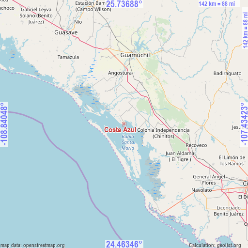
Costa Azul GPS coordinates[2]
25° 6' 6.588" North, 108° 8' 14.46" West
| Map corner | latitude | longitude |
|---|---|---|
| Upper-left | 25.73688°, | -108.84048° |
| Center: | 25.10183°, | -108.13735° |
| Lower-right: | 24.46346°, | -107.43423° |
| Map W x H: | 141.6×141.6 km | = 88×88mi |
| max Lat: | 32.7° ⇑8.1% North |
| Costa Azul: | 25.10183° |
| min Lat: | ⇓91.9% South 14.53588° |
| min Long | Costa Azul | max Long |
| -117.105° | -108.13735° | -86.73105° |
| W 4.3%⇐ | ⇒95.7% E |
Elevation
Elevation of Costa Azul is 7 m = 23 ft, and this is 1246.7 m = 4090 ft below average elevation for this country.
| Max E: |
3497 m = 11473 ft | 98.7% |
| Avg. | 1253.7 m = 4113 ft | |
| Costa Azul | 7 m = 23 ft | |
Min E: |
-1 m = -3 ft | 1.3% |
See also: Mexico elevation on elevation.city.
Geographical zone
Costa Azul is located in North temperate zone (between Tropic of Cancer and the Arctic Circle). Distance of this Northern Tropic circle is 185.1 km =115 mi to South.| Distance of | km | miles | from Costa Azul |
|---|---|---|---|
| North Pole | 7216 | 4483.8 | to North |
| Arctic Circle | 4610.1 | 2864.6 | to North |
| Tropic Cancer | 185.1 | 115 | to South |
| Equator | 2791.1 | 1734.3 | to South |


Nearby cities:
15 places around Costa Azul: (largest is in red/bold)
• Alhuey
30.7 km =19.1 mi,  1°
1°
• Angostura
29.5 km =18.3 mi,  355°
355°
• Batury
21.7 km =13.5 mi,  330°
330°
• Caitime
31.9 km =19.8 mi,  35°
35°
• Colonia Agrícola México (Palmitas)
19.4 km =12.1 mi,  87°
87°
• El Zapotillo
30 km =18.6 mi, 92°
• El Ébano
25.1 km =15.6 mi,  349°
349°
• Estación Acatita
25 km =15.5 mi,  24°
24°
• Gustavo Díaz Ordaz
18.8 km =11.7 mi,  13°
13°
• La Esperanza
27.9 km =17.3 mi, 349°
• La Palma
31.3 km =19.4 mi, 355°
• La Reforma
8.4 km =5.2 mi,  105°
105°
• Melchor Ocampo
25.2 km =15.7 mi,  104°
104°
• Playa Colorada
28.1 km =17.5 mi,  317°
317°
• Potrero de los Sánchez (Estación Techa)
23.8 km =14.8 mi, 87°
Sources, notices
• [Note1] Compared only with cities in Mexico existing in our database
• [Src1] Map data: © OpenStreetMap contributors (CC-BY-SA)
• [Src2] Other city data from geonames.org with taken over terms of usage.
• [Src3] Geographical zone / Annual Mean Temperature by Robert A. Rohde @ Wikipedia
