San Jerónimo Purenchecuaro geodata
San Jerónimo Purenchecuaro (Michoacán) is a populated place; located in Mexico in America/Mexico_City (GMT-6) time zone. With population of 1,798 people, there are 4843 cities with bigger population in this country. Compared to other cities in Mexico, 50.2% of cities are located further ↑North; 78.3% of cities are located further →East and 76.9% of cities have lower elevation than San Jerónimo Purenchecuaro. Note1
Current local time in San Jerónimo Purenchecuaro:
08:32 AM, WednesdayDifference from your time zone: hours


San Jerónimo Purenchecuaro GPS coordinates[2]
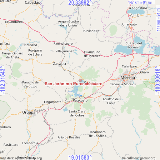
19° 40' 45.264" North, 101° 36' 44.28" West
| Map corner | latitude | longitude |
|---|---|---|
| Upper-left | 20.33992°, | -102.31543° |
| Center: | 19.67924°, | -101.6123° |
| Lower-right: | 19.01583°, | -100.90918° |
| Map W x H: | 147.2×147.2 km | = 91.5×91.5mi |
| max Lat: | 32.7° ⇑50.2% North |
| San Jerónimo Purenchecuaro: | 19.67924° |
| min Lat: | ⇓49.8% South 14.53588° |
| min Long | San Jerónimo P | max Long |
| -117.105° | -101.6123° | -86.73105° |
| W 21.7%⇐ | ⇒78.3% E |
Elevation
Elevation of San Jerónimo Purenchecuaro is 2065 m = 6775 ft, and this is 811.3 m = 2662 ft above average elevation for this country.
| Max E: |
3497 m = 11473 ft | 23.1% |
| San Jerónimo Purenchecuaro | 2065 m 6775 ft | |
| Avg. | 1253.7 m = 4113 ft | |
Min E: |
-1 m = -3 ft | 76.9% |
See also: Mexico elevation on elevation.city.
Geographical zone
San Jerónimo Purenchecuaro is located in North Torrid zone (between Equator and Tropic of Cancer). Distance of this Northern Tropic circle is 417.8 km =259.6 mi to North.| Distance of | km | miles | from San Jerónimo Purenchecuaro |
|---|---|---|---|
| North Pole | 7818.9 | 4858.4 | to North |
| Arctic Circle | 5213 | 3239.2 | to North |
| Tropic Cancer | 417.8 | 259.6 | to North |
| Equator | 2188.1 | 1359.6 | to South |


Nearby cities:
15 places around San Jerónimo Purenchecuaro: (largest is in red/bold)
• Comanjá
11.1 km =6.9 mi,  312°
312°
• Cucuchucho
10.9 km =6.8 mi,  190°
190°
• Ihuatzio
12.5 km =7.8 mi,  182°
182°
• Janitzio
12.5 km =7.8 mi,  199°
199°
• Lázaro Cárdenas (Colonia de Lázaro Cárdenas)
14 km =8.7 mi,  271°
271°
• Matugeo
6 km =3.7 mi,  356°
356°
• Napízaro
12.4 km =7.7 mi,  223°
223°
• Puácuaro
10.7 km =6.6 mi, 217°
• Quiroga
9.5 km =5.9 mi,  99°
99°
• San Andrés Ziróndaro
2.4 km =1.5 mi,  242°
242°
• Santa Fé de la Laguna
6.1 km =3.8 mi, 97°
• Santiago Azajo
8.4 km =5.2 mi,  291°
291°
• Tungüitiro
11.9 km =7.4 mi,  0°
0°
• Tzintzuntzán
6.7 km =4.2 mi,  147°
147°
• Zipiajo
14.3 km =8.9 mi,  26°
26°
Sources, notices
• [Note1] Compared only with cities in Mexico existing in our database
• [Src1] Map data: © OpenStreetMap contributors (CC-BY-SA)
• [Src2] Other city data from geonames.org with taken over terms of usage.
• [Src3] Geographical zone / Annual Mean Temperature by Robert A. Rohde @ Wikipedia
