Cofradía de Acuitapilco geodata
Cofradía de Acuitapilco (Nayarit) is a populated place; located in Mexico in America/Mazatlan (GMT-7) time zone. With population of 519 people, there are 16226 cities with bigger population in this country. Compared to other cities in Mexico, 80.4% of cities are located further ↓South; 91% of cities are located further →East and 63.6% of cities have higher elevation than Cofradía de Acuitapilco. Note1
Current local time in Cofradía de Acuitapilco:
07:28 AM, WednesdayDifference from your time zone: hours


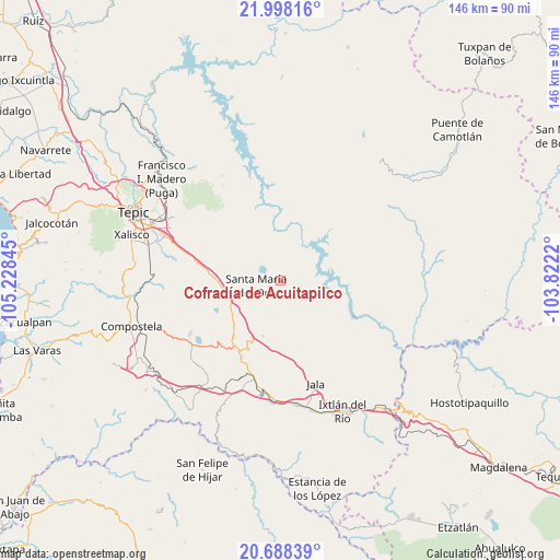
Cofradía de Acuitapilco GPS coordinates[2]
21° 20' 41.064" North, 104° 31' 31.152" West
| Map corner | latitude | longitude |
|---|---|---|
| Upper-left | 21.99816°, | -105.22845° |
| Center: | 21.34474°, | -104.52532° |
| Lower-right: | 20.68839°, | -103.8222° |
| Map W x H: | 145.6×145.6 km | = 90.5×90.5mi |
| max Lat: | 32.7° ⇑19.6% North |
| Cofradía de Acuitapilco: | 21.34474° |
| min Lat: | ⇓80.4% South 14.53588° |
| min Long | Cofradía de Ac | max Long |
| -117.105° | -104.52532° | -86.73105° |
| W 9%⇐ | ⇒91% E |
Elevation
Elevation of Cofradía de Acuitapilco is 774 m = 2539 ft, and this is 479.7 m = 1574 ft below average elevation for this country.
| Max E: |
3497 m = 11473 ft | 63.6% |
| Avg. | 1253.7 m = 4113 ft | |
| Cofradía de Acuitapilco | 774 m = 2539 ft | |
Min E: |
-1 m = -3 ft | 36.4% |
See also: Mexico elevation on elevation.city.
Geographical zone
Cofradía de Acuitapilco is located in North Torrid zone (between Equator and Tropic of Cancer). Distance of this Northern Tropic circle is 232.6 km =144.5 mi to North.| Distance of | km | miles | from Cofradía de Acuitapilco |
|---|---|---|---|
| North Pole | 7633.7 | 4743.4 | to North |
| Arctic Circle | 5027.9 | 3124.2 | to North |
| Tropic Cancer | 232.6 | 144.5 | to North |
| Equator | 2373.3 | 1474.7 | to South |


Nearby cities:
15 places around Cofradía de Acuitapilco: (largest is in red/bold)
• Cerro Blanco
10.5 km =6.5 mi,  290°
290°
• Chapalilla
20.9 km =13 mi,  213°
213°
• El Buruato
7.9 km =4.9 mi,  337°
337°
• El Limón
12 km =7.5 mi,  276°
276°
• La Labor
20.3 km =12.6 mi, 278°
• Mojarras
12.5 km =7.8 mi,  316°
316°
• San Leonel
18.3 km =11.4 mi,  271°
271°
• San Luis de Lozada
25.6 km =15.9 mi,  313°
313°
• Santa Isabel
22.6 km =14 mi, 206°
• Santa María del Oro
6.5 km =4 mi,  259°
259°
• Tequepexpan
15.1 km =9.4 mi,  197°
197°
• Tetitlán
25.8 km =16 mi, 201°
• Uzeta
26.7 km =16.6 mi, 197°
• Valle Verde
26.8 km =16.7 mi, 201°
• Zapotanito
9.7 km =6 mi,  243°
243°
Sources, notices
• [Note1] Compared only with cities in Mexico existing in our database
• [Src1] Map data: © OpenStreetMap contributors (CC-BY-SA)
• [Src2] Other city data from geonames.org with taken over terms of usage.
• [Src3] Geographical zone / Annual Mean Temperature by Robert A. Rohde @ Wikipedia
