Las Cañas geodata
Las Cañas (Michoacán) is a populated place; located in Mexico in America/Mexico_City (GMT-6) time zone. With population of 1,076 people, there are 8105 cities with bigger population in this country. Compared to other cities in Mexico, 71.8% of cities are located further ↑North; 80.8% of cities are located further →East and 71.7% of cities have higher elevation than Las Cañas. Note1


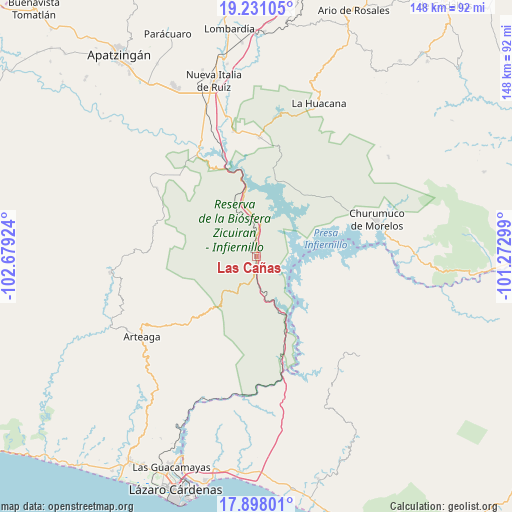
Las Cañas GPS coordinates[2]
18° 33' 56.988" North, 101° 58' 33.996" West
| Map corner | latitude | longitude |
|---|---|---|
| Upper-left | 19.23105°, | -102.67924° |
| Center: | 18.56583°, | -101.97611° |
| Lower-right: | 17.89801°, | -101.27299° |
| Map W x H: | 148.2×148.2 km | = 92.1×92.1mi |
| max Lat: | 32.7° ⇑71.8% North |
| Las Cañas: | 18.56583° |
| min Lat: | ⇓28.2% South 14.53588° |
| min Long | Las Cañas | max Long |
| -117.105° | -101.97611° | -86.73105° |
| W 19.2%⇐ | ⇒80.8% E |
Elevation
Elevation of Las Cañas is 341 m = 1119 ft, and this is 912.7 m = 2994 ft below average elevation for this country.
| Max E: |
3497 m = 11473 ft | 71.7% |
| Avg. | 1253.7 m = 4113 ft | |
| Las Cañas | 341 m = 1119 ft | |
Min E: |
-1 m = -3 ft | 28.3% |
See also: Mexico elevation on elevation.city.
Geographical zone
Las Cañas is located in North Torrid zone (between Equator and Tropic of Cancer). Distance of this Northern Tropic circle is 541.6 km =336.5 mi to North.| Distance of | km | miles | from Las Cañas |
|---|---|---|---|
| North Pole | 7942.7 | 4935.4 | to North |
| Arctic Circle | 5336.8 | 3316.1 | to North |
| Tropic Cancer | 541.6 | 336.5 | to North |
| Equator | 2064.3 | 1282.7 | to South |


Nearby cities:
15 places around Las Cañas: (largest is in red/bold)
• Arteaga
40.5 km =25.2 mi,  235°
235°
• Bellas Fuentes (Nuevo Centro)
20 km =12.4 mi,  350°
350°
• Churumuco de Morelos
36.3 km =22.6 mi,  72°
72°
• Coahuayutla de Guerrero
37.7 km =23.4 mi,  137°
137°
• Cupuán del Río
32.5 km =20.2 mi,  316°
316°
• El Chauz
36.9 km =22.9 mi, 349°
• Gambara
43.2 km =26.8 mi,  340°
340°
• General Francisco Villa
34.9 km =21.7 mi,  304°
304°
• Infiernillo (Morelos de Infiernillo)
32.5 km =20.2 mi,  165°
165°
• La Mira Tumbiscatio
34.9 km =21.7 mi,  291°
291°
• Los Ciriancitos
13.8 km =8.6 mi, 348°
• Nuevo Capirio
36.5 km =22.7 mi, 335°
• Palma de Huaro
29.9 km =18.6 mi,  53°
53°
• Tumbiscatío de Ruiz
42.6 km =26.5 mi,  264°
264°
• Zicuirán
34.7 km =21.6 mi,  1°
1°
Sources, notices
• [Note1] Compared only with cities in Mexico existing in our database
• [Src1] Map data: © OpenStreetMap contributors (CC-BY-SA)
• [Src2] Other city data from geonames.org with taken over terms of usage.
• [Src3] Geographical zone / Annual Mean Temperature by Robert A. Rohde @ Wikipedia
