Churintzio geodata
Churintzio (Michoacán) is a populated place; located in Mexico in America/Mexico_City (GMT-6) time zone. With population of 2,592 people, there are 3423 cities with bigger population in this country. Compared to other cities in Mexico, 60.3% of cities are located further ↓South; 81.3% of cities are located further →East and 66.4% of cities have lower elevation than Churintzio. Note1


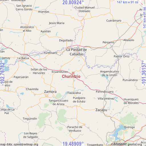
Churintzio GPS coordinates[2]
20° 9' 2.016" North, 102° 3' 52.884" West
| Map corner | latitude | longitude |
|---|---|---|
| Upper-left | 20.80924°, | -102.76782° |
| Center: | 20.15056°, | -102.06469° |
| Lower-right: | 19.48909°, | -101.36157° |
| Map W x H: | 146.8×146.8 km | = 91.2×91.2mi |
| max Lat: | 32.7° ⇑39.7% North |
| Churintzio: | 20.15056° |
| min Lat: | ⇓60.3% South 14.53588° |
| min Long | Churintzio | max Long |
| -117.105° | -102.06469° | -86.73105° |
| W 18.7%⇐ | ⇒81.3% E |
Elevation
Elevation of Churintzio is 1858 m = 6096 ft, and this is 604.3 m = 1983 ft above average elevation for this country.
| Max E: |
3497 m = 11473 ft | 33.6% |
| Churintzio | 1858 m 6096 ft | |
| Avg. | 1253.7 m = 4113 ft | |
Min E: |
-1 m = -3 ft | 66.4% |
See also: Mexico elevation on elevation.city.
Geographical zone
Churintzio is located in North Torrid zone (between Equator and Tropic of Cancer). Distance of this Northern Tropic circle is 365.4 km =227 mi to North.| Distance of | km | miles | from Churintzio |
|---|---|---|---|
| North Pole | 7766.5 | 4825.9 | to North |
| Arctic Circle | 5160.6 | 3206.6 | to North |
| Tropic Cancer | 365.4 | 227 | to North |
| Equator | 2240.5 | 1392.2 | to South |


Nearby cities:
15 places around Churintzio: (largest is in red/bold)
• Atacheo de Regalado
16.4 km =10.2 mi,  231°
231°
• Ecuandureo
13.5 km =8.4 mi,  275°
275°
• El Colorado
13.5 km =8.4 mi,  81°
81°
• El Palmito
14.2 km =8.8 mi,  61°
61°
• La Noria
5.5 km =3.4 mi,  326°
326°
• La Soledad
17.4 km =10.8 mi,  299°
299°
• La Tepuza
15 km =9.3 mi, 75°
• Las Fuentes
16.1 km =10 mi,  273°
273°
• Los Guajes
14.7 km =9.1 mi, 326°
• Numarán
16.7 km =10.4 mi,  45°
45°
• Paredones
11.8 km =7.3 mi,  0°
0°
• Penjamillo de Degollado
14.5 km =9 mi,  110°
110°
• Rincón Grande
13.5 km =8.4 mi, 304°
• Tirimácuaro (Valanciana)
17.1 km =10.6 mi, 106°
• Zináparo
7.4 km =4.6 mi,  70°
70°
Sources, notices
• [Note1] Compared only with cities in Mexico existing in our database
• [Src1] Map data: © OpenStreetMap contributors (CC-BY-SA)
• [Src2] Other city data from geonames.org with taken over terms of usage.
• [Src3] Geographical zone / Annual Mean Temperature by Robert A. Rohde @ Wikipedia
