Numarán geodata
Numarán (Michoacán) is a seat of a second-order administrative division; located in Mexico in America/Mexico_City (GMT-6) time zone. With population of 4,944 people, there are 1868 cities with bigger population in this country. Compared to other cities in Mexico, 62.6% of cities are located further ↓South; 80.6% of cities are located further →East and 57.8% of cities have lower elevation than Numarán. Note1


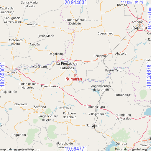
Numarán GPS coordinates[2]
20° 15' 20.88" North, 101° 56' 59.568" West
| Map corner | latitude | longitude |
|---|---|---|
| Upper-left | 20.91403°, | -102.65301° |
| Center: | 20.2558°, | -101.94988° |
| Lower-right: | 19.59477°, | -101.24676° |
| Map W x H: | 146.7×146.7 km | = 91.2×91.2mi |
| max Lat: | 32.7° ⇑37.4% North |
| Numarán: | 20.2558° |
| min Lat: | ⇓62.6% South 14.53588° |
| min Long | Numarán | max Long |
| -117.105° | -101.94988° | -86.73105° |
| W 19.4%⇐ | ⇒80.6% E |
Elevation
Elevation of Numarán is 1686 m = 5531 ft, and this is 432.3 m = 1418 ft above average elevation for this country.
| Max E: |
3497 m = 11473 ft | 42.2% |
| Numarán | 1686 m 5531 ft | |
| Avg. | 1253.7 m = 4113 ft | |
Min E: |
-1 m = -3 ft | 57.8% |
See also: Mexico elevation on elevation.city.
Geographical zone
Numarán is located in North Torrid zone (between Equator and Tropic of Cancer). Distance of this Northern Tropic circle is 353.7 km =219.8 mi to North.| Distance of | km | miles | from Numarán |
|---|---|---|---|
| North Pole | 7754.8 | 4818.6 | to North |
| Arctic Circle | 5148.9 | 3199.4 | to North |
| Tropic Cancer | 353.7 | 219.8 | to North |
| Equator | 2252.2 | 1399.5 | to South |


Nearby cities:
15 places around Numarán: (largest is in red/bold)
• Cañada de Ramírez
4.7 km =2.9 mi,  342°
342°
• Cerritos Blancos
5.5 km =3.4 mi,  111°
111°
• Cruces de Rojas
6.1 km =3.8 mi,  93°
93°
• El Colorado
9.8 km =6.1 mi,  171°
171°
• El Palmito
4.9 km =3 mi, 174°
• La Cal Grande
9.8 km =6.1 mi,  3°
3°
• La Estancia del Refugio
4.9 km =3 mi,  22°
22°
• La Lobera
5.3 km =3.3 mi,  52°
52°
• La Tepuza
8.3 km =5.2 mi,  161°
161°
• Lagunillas
8.4 km =5.2 mi,  40°
40°
• Las Cañadas
5.5 km =3.4 mi,  327°
327°
• Mezquite de Luna
7.6 km =4.7 mi, 52°
• Veredas
10.3 km =6.4 mi, 89°
• Villas de las Lomas
6.3 km =3.9 mi,  319°
319°
• Zaragoza
9.9 km =6.2 mi,  351°
351°
Sources, notices
• [Note1] Compared only with cities in Mexico existing in our database
• [Src1] Map data: © OpenStreetMap contributors (CC-BY-SA)
• [Src2] Other city data from geonames.org with taken over terms of usage.
• [Src3] Geographical zone / Annual Mean Temperature by Robert A. Rohde @ Wikipedia
