Chupícuaro geodata
Chupícuaro (Michoacán) is a populated place; located in Mexico in America/Mexico_City (GMT-6) time zone. With population of 770 people, there are 11354 cities with bigger population in this country. Compared to other cities in Mexico, 57% of cities are located further ↓South; 74.8% of cities are located further →East and 68.9% of cities have lower elevation than Chupícuaro. Note1


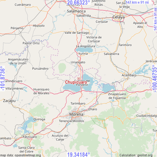
Chupícuaro GPS coordinates[2]
20° 0' 14.112" North, 101° 10' 13.692" West
| Map corner | latitude | longitude |
|---|---|---|
| Upper-left | 20.66323°, | -101.8736° |
| Center: | 20.00392°, | -101.17047° |
| Lower-right: | 19.34184°, | -100.46735° |
| Map W x H: | 146.9×146.9 km | = 91.3×91.3mi |
| max Lat: | 32.7° ⇑43% North |
| Chupícuaro: | 20.00392° |
| min Lat: | ⇓57% South 14.53588° |
| min Long | Chupícuaro | max Long |
| -117.105° | -101.17047° | -86.73105° |
| W 25.2%⇐ | ⇒74.8% E |
Elevation
Elevation of Chupícuaro is 1905 m = 6250 ft, and this is 651.3 m = 2137 ft above average elevation for this country.
| Max E: |
3497 m = 11473 ft | 31.1% |
| Chupícuaro | 1905 m 6250 ft | |
| Avg. | 1253.7 m = 4113 ft | |
Min E: |
-1 m = -3 ft | 68.9% |
See also: Mexico elevation on elevation.city.
Geographical zone
Chupícuaro is located in North Torrid zone (between Equator and Tropic of Cancer). Distance of this Northern Tropic circle is 381.7 km =237.2 mi to North.| Distance of | km | miles | from Chupícuaro |
|---|---|---|---|
| North Pole | 7782.8 | 4836 | to North |
| Arctic Circle | 5176.9 | 3216.8 | to North |
| Tropic Cancer | 381.7 | 237.2 | to North |
| Equator | 2224.2 | 1382.1 | to South |


Nearby cities:
15 places around Chupícuaro: (largest is in red/bold)
• Capacho
7.7 km =4.8 mi,  235°
235°
• Cuamio
3.9 km =2.4 mi,  30°
30°
• Cuaracurío
6.8 km =4.2 mi,  20°
20°
• Cuitzeo del Porvenir
4.7 km =2.9 mi,  142°
142°
• Doctor Miguel Silva (San Guillermo)
4.3 km =2.7 mi,  185°
185°
• El Derramadero
9.6 km =6 mi, 26°
• El Salto
5.3 km =3.3 mi,  346°
346°
• Jéruco
3.6 km =2.2 mi,  178°
178°
• Piñícuaro
8.8 km =5.5 mi,  303°
303°
• Rinconadas del Bosque
9.5 km =5.9 mi,  342°
342°
• San Agustín del Pulque
11.1 km =6.9 mi,  114°
114°
• San José Cuaracurio
11.1 km =6.9 mi,  6°
6°
• San José Cuaro
8.7 km =5.4 mi,  258°
258°
• San Juan Benito Juárez (San Juan Tararameo)
10.6 km =6.6 mi,  155°
155°
• San Rafael del Carrizal
10.5 km =6.5 mi,  51°
51°
Sources, notices
• [Note1] Compared only with cities in Mexico existing in our database
• [Src1] Map data: © OpenStreetMap contributors (CC-BY-SA)
• [Src2] Other city data from geonames.org with taken over terms of usage.
• [Src3] Geographical zone / Annual Mean Temperature by Robert A. Rohde @ Wikipedia
