El Salto geodata
El Salto (Michoacán) is a populated place; located in Mexico in America/Mexico_City (GMT-6) time zone. With population of 676 people, there are 12846 cities with bigger population in this country. Compared to other cities in Mexico, 58% of cities are located further ↓South; 74.9% of cities are located further →East and 72.4% of cities have lower elevation than El Salto. Note1


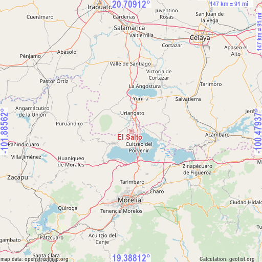
El Salto GPS coordinates[2]
20° 3' 0.036" North, 101° 10' 56.964" West
| Map corner | latitude | longitude |
|---|---|---|
| Upper-left | 20.70912°, | -101.88562° |
| Center: | 20.05001°, | -101.18249° |
| Lower-right: | 19.38812°, | -100.47937° |
| Map W x H: | 146.9×146.9 km | = 91.3×91.3mi |
| max Lat: | 32.7° ⇑42% North |
| El Salto: | 20.05001° |
| min Lat: | ⇓58% South 14.53588° |
| min Long | El Salto | max Long |
| -117.105° | -101.18249° | -86.73105° |
| W 25.1%⇐ | ⇒74.9% E |
Elevation
Elevation of El Salto is 1975 m = 6480 ft, and this is 721.3 m = 2366 ft above average elevation for this country.
| Max E: |
3497 m = 11473 ft | 27.6% |
| El Salto | 1975 m 6480 ft | |
| Avg. | 1253.7 m = 4113 ft | |
Min E: |
-1 m = -3 ft | 72.4% |
See also: Mexico elevation on elevation.city.
Geographical zone
El Salto is located in North Torrid zone (between Equator and Tropic of Cancer). Distance of this Northern Tropic circle is 376.6 km =234 mi to North.| Distance of | km | miles | from El Salto |
|---|---|---|---|
| North Pole | 7777.7 | 4832.8 | to North |
| Arctic Circle | 5171.8 | 3213.6 | to North |
| Tropic Cancer | 376.6 | 234 | to North |
| Equator | 2229.4 | 1385.3 | to South |


Nearby cities:
15 places around El Salto: (largest is in red/bold)
• Capacho
10.8 km =6.7 mi,  208°
208°
• Chupícuaro
5.3 km =3.3 mi,  166°
166°
• Cuamio
3.7 km =2.3 mi,  119°
119°
• Cuaracurío
3.8 km =2.4 mi,  71°
71°
• Cuitzeo del Porvenir
9.8 km =6.1 mi,  154°
154°
• Doctor Miguel Silva (San Guillermo)
9.4 km =5.8 mi, 174°
• El Derramadero
6.6 km =4.1 mi,  58°
58°
• Jéruco
8.8 km =5.5 mi, 171°
• Moroleón
8.5 km =5.3 mi,  353°
353°
• Piñícuaro
6.1 km =3.8 mi,  267°
267°
• Rinconadas del Bosque
4.3 km =2.7 mi,  337°
337°
• San José Cuaracurio
6.4 km =4 mi,  23°
23°
• San José Cuaro
10 km =6.2 mi,  226°
226°
• San Rafael del Carrizal
9.6 km =6 mi,  81°
81°
• Uriangato
10.1 km =6.3 mi,  359°
359°
Sources, notices
• [Note1] Compared only with cities in Mexico existing in our database
• [Src1] Map data: © OpenStreetMap contributors (CC-BY-SA)
• [Src2] Other city data from geonames.org with taken over terms of usage.
• [Src3] Geographical zone / Annual Mean Temperature by Robert A. Rohde @ Wikipedia
