San Rafael del Carrizal geodata
San Rafael del Carrizal (Michoacán) is a populated place; located in Mexico in America/Mexico_City (GMT-6) time zone. With population of 771 people, there are 11338 cities with bigger population in this country. Compared to other cities in Mexico, 58.4% of cities are located further ↓South; 74.2% of cities are located further →East and 65.4% of cities have lower elevation than San Rafael del Carrizal. Note1
Current local time in San Rafael del Carrizal:
06:51 AM, WednesdayDifference from your time zone: hours


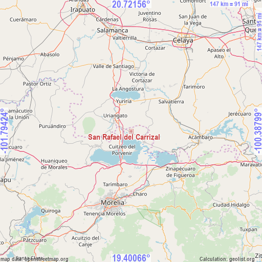
San Rafael del Carrizal GPS coordinates[2]
20° 3' 45" North, 101° 5' 27.996" West
| Map corner | latitude | longitude |
|---|---|---|
| Upper-left | 20.72156°, | -101.79424° |
| Center: | 20.0625°, | -101.09111° |
| Lower-right: | 19.40066°, | -100.38799° |
| Map W x H: | 146.9×146.9 km | = 91.3×91.3mi |
| max Lat: | 32.7° ⇑41.6% North |
| San Rafael del Carrizal: | 20.0625° |
| min Lat: | ⇓58.4% South 14.53588° |
| min Long | San Rafael del | max Long |
| -117.105° | -101.09111° | -86.73105° |
| W 25.8%⇐ | ⇒74.2% E |
Elevation
Elevation of San Rafael del Carrizal is 1840 m = 6037 ft, and this is 586.3 m = 1924 ft above average elevation for this country.
| Max E: |
3497 m = 11473 ft | 34.6% |
| San Rafael del Carrizal | 1840 m 6037 ft | |
| Avg. | 1253.7 m = 4113 ft | |
Min E: |
-1 m = -3 ft | 65.4% |
See also: Mexico elevation on elevation.city.
Geographical zone
San Rafael del Carrizal is located in North Torrid zone (between Equator and Tropic of Cancer). Distance of this Northern Tropic circle is 375.2 km =233.1 mi to North.| Distance of | km | miles | from San Rafael del Carrizal |
|---|---|---|---|
| North Pole | 7776.3 | 4832 | to North |
| Arctic Circle | 5170.4 | 3212.7 | to North |
| Tropic Cancer | 375.2 | 233.1 | to North |
| Equator | 2230.7 | 1386.1 | to South |


Nearby cities:
15 places around San Rafael del Carrizal: (largest is in red/bold)
• Chupícuaro
10.5 km =6.5 mi,  231°
231°
• Colonia Juárez
10.9 km =6.8 mi,  326°
326°
• Cuamio
7.1 km =4.4 mi,  243°
243°
• Cuaracurío
5.9 km =3.7 mi,  268°
268°
• El Charco
10 km =6.2 mi,  336°
336°
• El Derramadero
4.5 km =2.8 mi,  297°
297°
• El Salteador
8.7 km =5.4 mi,  9°
9°
• El Salto
9.6 km =6 mi,  261°
261°
• El Timbinal
5.7 km =3.5 mi,  52°
52°
• Huacao
7.4 km =4.6 mi,  106°
106°
• La Lobera
3.6 km =2.2 mi,  131°
131°
• Mariano Escobedo
11.3 km =7 mi,  164°
164°
• San Agustín del Pulque
11.3 km =7 mi,  170°
170°
• San José Cuaracurio
8.3 km =5.2 mi, 302°
• Santa Ana Maya
9.5 km =5.9 mi, 130°
Sources, notices
• [Note1] Compared only with cities in Mexico existing in our database
• [Src1] Map data: © OpenStreetMap contributors (CC-BY-SA)
• [Src2] Other city data from geonames.org with taken over terms of usage.
• [Src3] Geographical zone / Annual Mean Temperature by Robert A. Rohde @ Wikipedia
