La Encarnación geodata
La Encarnación (Guanajuato) is a populated place; located in Mexico in America/Mexico_City (GMT-6) time zone. With population of 803 people, there are 10877 cities with bigger population in this country. Compared to other cities in Mexico, 58.6% of cities are located further ↓South; 70.6% of cities are located further →East and 69.3% of cities have lower elevation than La Encarnación. Note1


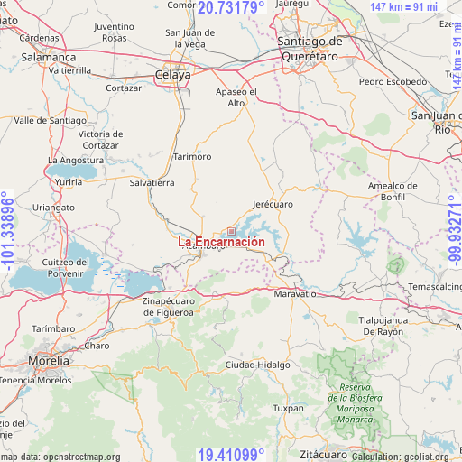
La Encarnación GPS coordinates[2]
20° 4' 22.008" North, 100° 38' 8.988" West
| Map corner | latitude | longitude |
|---|---|---|
| Upper-left | 20.73179°, | -101.33896° |
| Center: | 20.07278°, | -100.63583° |
| Lower-right: | 19.41099°, | -99.93271° |
| Map W x H: | 146.9×146.9 km | = 91.3×91.3mi |
| max Lat: | 32.7° ⇑41.4% North |
| La Encarnación: | 20.07278° |
| min Lat: | ⇓58.6% South 14.53588° |
| min Long | La Encarnación | max Long |
| -117.105° | -100.63583° | -86.73105° |
| W 29.4%⇐ | ⇒70.6% E |
Elevation
Elevation of La Encarnación is 1913 m = 6276 ft, and this is 659.3 m = 2163 ft above average elevation for this country.
| Max E: |
3497 m = 11473 ft | 30.7% |
| La Encarnación | 1913 m 6276 ft | |
| Avg. | 1253.7 m = 4113 ft | |
Min E: |
-1 m = -3 ft | 69.3% |
See also: Mexico elevation on elevation.city.
Geographical zone
La Encarnación is located in North Torrid zone (between Equator and Tropic of Cancer). Distance of this Northern Tropic circle is 374 km =232.4 mi to North.| Distance of | km | miles | from La Encarnación |
|---|---|---|---|
| North Pole | 7775.2 | 4831.3 | to North |
| Arctic Circle | 5169.3 | 3212.1 | to North |
| Tropic Cancer | 374 | 232.4 | to North |
| Equator | 2231.9 | 1386.8 | to South |


Nearby cities:
15 places around La Encarnación: (largest is in red/bold)
• Acámbaro
10.1 km =6.3 mi,  242°
242°
• Agua Caliente
5.5 km =3.4 mi,  228°
228°
• Arroyo Colorado
7.3 km =4.5 mi,  168°
168°
• Arroyo de la Luna
7.1 km =4.4 mi,  141°
141°
• El Maguey
6.2 km =3.9 mi,  302°
302°
• El Terrero
9.8 km =6.1 mi,  41°
41°
• Estanzuela de Razo
11.5 km =7.1 mi,  78°
78°
• Gaytán del Refugio
9 km =5.6 mi,  338°
338°
• Jaral del Refugio
10.2 km =6.3 mi, 297°
• San Cayetano
2.5 km =1.6 mi,  287°
287°
• San Juan Viejo
12.1 km =7.5 mi,  281°
281°
• San Miguel
3.9 km =2.4 mi,  198°
198°
• San Miguel Curinhuato
11.2 km =7 mi,  149°
149°
• Santiaguillo
4.3 km =2.7 mi,  349°
349°
• Solís
5.1 km =3.2 mi, 241°
Sources, notices
• [Note1] Compared only with cities in Mexico existing in our database
• [Src1] Map data: © OpenStreetMap contributors (CC-BY-SA)
• [Src2] Other city data from geonames.org with taken over terms of usage.
• [Src3] Geographical zone / Annual Mean Temperature by Robert A. Rohde @ Wikipedia
