La Estanzuela geodata
La Estanzuela (Jalisco) is a populated place; located in Mexico in America/Mexico_City (GMT-6) time zone. With population of 2,199 people, there are 3993 cities with bigger population in this country. Compared to other cities in Mexico, 71.2% of cities are located further ↓South; 89.5% of cities are located further →East and 53.6% of cities have higher elevation than La Estanzuela. Note1


La Estanzuela GPS coordinates[2]
20° 40' 8.076" North, 103° 49' 33.924" West
| Map corner | latitude | longitude |
|---|---|---|
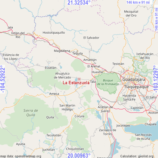
| Upper-left | 21.32534°, | -104.52922° |
| Center: | 20.66891°, | -103.82609° |
| Lower-right: | 20.00963°, | -103.12297° |
| Map W x H: | 146.3×146.3 km | = 90.9×90.9mi |
| max Lat: | 32.7° ⇑28.8% North |
| La Estanzuela: | 20.66891° |
| min Lat: | ⇓71.2% South 14.53588° |
| min Long | La Estanzuela | max Long |
| -117.105° | -103.82609° | -86.73105° |
| W 10.5%⇐ | ⇒89.5% E |
Elevation
Elevation of La Estanzuela is 1264 m = 4147 ft, and this is 10.3 m = 34 ft above average elevation for this country.
| Max E: |
3497 m = 11473 ft | 53.6% |
| La Estanzuela | 1264 m 4147 ft | |
| Avg. | 1253.7 m = 4113 ft | |
Min E: |
-1 m = -3 ft | 46.4% |
See also: Mexico elevation on elevation.city.
Geographical zone
La Estanzuela is located in North Torrid zone (between Equator and Tropic of Cancer). Distance of this Northern Tropic circle is 307.8 km =191.3 mi to North.| Distance of | km | miles | from La Estanzuela |
|---|---|---|---|
| North Pole | 7708.9 | 4790.1 | to North |
| Arctic Circle | 5103 | 3170.9 | to North |
| Tropic Cancer | 307.8 | 191.3 | to North |
| Equator | 2298.2 | 1428 | to South |


Nearby cities:
15 places around La Estanzuela: (largest is in red/bold)
• Buenavista
11.5 km =7.1 mi,  193°
193°
• Castro Urdiales
8 km =5 mi,  175°
175°
• Cuisillos
8.5 km =5.3 mi,  140°
140°
• El Amarillo
8.3 km =5.2 mi,  239°
239°
• El Carmen
9.1 km =5.7 mi,  259°
259°
• El Ranchito (San Isidro)
8.7 km =5.4 mi,  149°
149°
• El Refugio
9 km =5.6 mi,  88°
88°
• La Vega
10.1 km =6.3 mi,  199°
199°
• Los Ruiseñores
14.8 km =9.2 mi,  71°
71°
• Portes Gil
11.7 km =7.3 mi, 264°
• Punta de la Vega
11.5 km =7.1 mi,  220°
220°
• San Juan de los Arcos
13.2 km =8.2 mi,  122°
122°
• Tala
13.1 km =8.1 mi,  97°
97°
• Teuchitlán
3 km =1.9 mi,  306°
306°
• Trapiche de Abra
14.4 km =8.9 mi, 177°
Sources, notices
• [Note1] Compared only with cities in Mexico existing in our database
• [Src1] Map data: © OpenStreetMap contributors (CC-BY-SA)
• [Src2] Other city data from geonames.org with taken over terms of usage.
• [Src3] Geographical zone / Annual Mean Temperature by Robert A. Rohde @ Wikipedia
