Amazcala geodata
Amazcala (Querétaro) is a populated place; located in Mexico in America/Mexico_City (GMT-6) time zone. With population of 5,768 people, there are 1612 cities with bigger population in this country. Compared to other cities in Mexico, 71.7% of cities are located further ↓South; 67% of cities are located further →East and 69.8% of cities have lower elevation than Amazcala. Note1


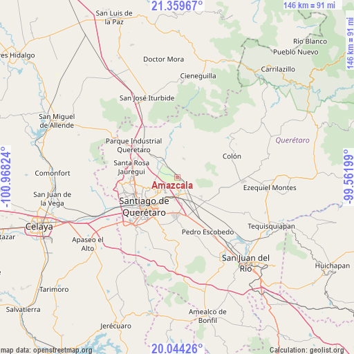
Amazcala GPS coordinates[2]
20° 42' 12.204" North, 100° 15' 54.396" West
| Map corner | latitude | longitude |
|---|---|---|
| Upper-left | 21.35967°, | -100.96824° |
| Center: | 20.70339°, | -100.26511° |
| Lower-right: | 20.04426°, | -99.56199° |
| Map W x H: | 146.3×146.3 km | = 90.9×90.9mi |
| max Lat: | 32.7° ⇑28.3% North |
| Amazcala: | 20.70339° |
| min Lat: | ⇓71.7% South 14.53588° |
| min Long | Amazcala | max Long |
| -117.105° | -100.26511° | -86.73105° |
| W 33%⇐ | ⇒67% E |
Elevation
Elevation of Amazcala is 1920 m = 6299 ft, and this is 666.3 m = 2186 ft above average elevation for this country.
| Max E: |
3497 m = 11473 ft | 30.2% |
| Amazcala | 1920 m 6299 ft | |
| Avg. | 1253.7 m = 4113 ft | |
Min E: |
-1 m = -3 ft | 69.8% |
See also: Mexico elevation on elevation.city.
Geographical zone
Amazcala is located in North Torrid zone (between Equator and Tropic of Cancer). Distance of this Northern Tropic circle is 303.9 km =188.8 mi to North.| Distance of | km | miles | from Amazcala |
|---|---|---|---|
| North Pole | 7705.1 | 4787.7 | to North |
| Arctic Circle | 5099.2 | 3168.5 | to North |
| Tropic Cancer | 303.9 | 188.8 | to North |
| Equator | 2302 | 1430.4 | to South |


Nearby cities:
15 places around Amazcala: (largest is in red/bold)
• Alfajayucan
7.5 km =4.7 mi,  41°
41°
• Atongo
8.2 km =5.1 mi,  18°
18°
• Cerro Prieto
6.5 km =4 mi,  203°
203°
• El Lobo
7.1 km =4.4 mi,  66°
66°
• Guadalupe la Venta
7.9 km =4.9 mi,  144°
144°
• Hacienda la Cruz [Fraccionamiento]
7.8 km =4.8 mi,  178°
178°
• La Griega
4.9 km =3 mi,  147°
147°
• La Trinidad
8.4 km =5.2 mi, 201°
• San Miguel Amazcala
6.1 km =3.8 mi,  30°
30°
• San Rafael
5.9 km =3.7 mi,  338°
338°
• San Vicente Ferrer
8.8 km =5.5 mi,  287°
287°
• Santa Cruz
4.2 km =2.6 mi,  282°
282°
• Santa Fe Libertadores
4.4 km =2.7 mi,  174°
174°
• Santa María Begoña
7.3 km =4.5 mi,  311°
311°
• Santa María Ticomán
3.7 km =2.3 mi, 177°
Sources, notices
• [Note1] Compared only with cities in Mexico existing in our database
• [Src1] Map data: © OpenStreetMap contributors (CC-BY-SA)
• [Src2] Other city data from geonames.org with taken over terms of usage.
• [Src3] Geographical zone / Annual Mean Temperature by Robert A. Rohde @ Wikipedia
