Aguililla geodata
Aguililla (Michoacán) is a seat of a second-order administrative division; located in Mexico in America/Mexico_City (GMT-6) time zone. With population of 8,801 people, there are 1078 cities with bigger population in this country. Compared to other cities in Mexico, 69.7% of cities are located further ↑North; 85.1% of cities are located further →East and 61.2% of cities have higher elevation than Aguililla. Note1


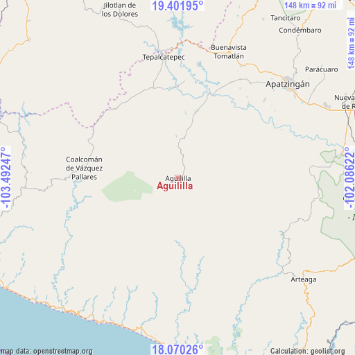
Aguililla GPS coordinates[2]
18° 44' 14.712" North, 102° 47' 21.624" West
| Map corner | latitude | longitude |
|---|---|---|
| Upper-left | 19.40195°, | -103.49247° |
| Center: | 18.73742°, | -102.78934° |
| Lower-right: | 18.07026°, | -102.08622° |
| Map W x H: | 148.1×148.1 km | = 92×92mi |
| max Lat: | 32.7° ⇑69.7% North |
| Aguililla: | 18.73742° |
| min Lat: | ⇓30.3% South 14.53588° |
| min Long | Aguililla | max Long |
| -117.105° | -102.78934° | -86.73105° |
| W 14.9%⇐ | ⇒85.1% E |
Elevation
Elevation of Aguililla is 923 m = 3028 ft, and this is 330.7 m = 1085 ft below average elevation for this country.
| Max E: |
3497 m = 11473 ft | 61.2% |
| Avg. | 1253.7 m = 4113 ft | |
| Aguililla | 923 m = 3028 ft | |
Min E: |
-1 m = -3 ft | 38.8% |
See also: Mexico elevation on elevation.city.
Geographical zone
Aguililla is located in North Torrid zone (between Equator and Tropic of Cancer). Distance of this Northern Tropic circle is 522.5 km =324.7 mi to North.| Distance of | km | miles | from Aguililla |
|---|---|---|---|
| North Pole | 7923.7 | 4923.6 | to North |
| Arctic Circle | 5317.8 | 3304.3 | to North |
| Tropic Cancer | 522.5 | 324.7 | to North |
| Equator | 2083.4 | 1294.6 | to South |


Nearby cities:
15 places around Aguililla: (largest is in red/bold)
• Bonifacio Moreno (El Aguaje)
29.5 km =18.3 mi,  16°
16°
• Buenavistilla (La Garita)
42.5 km =26.4 mi, 23°
• Coalcomán de Vázquez Pallares
39.3 km =24.4 mi,  276°
276°
• División del Norte
42.6 km =26.5 mi,  25°
25°
• Dos Aguas
16.4 km =10.2 mi,  298°
298°
• El Naranjo de Chila
27 km =16.8 mi,  40°
40°
• El Terrero
38 km =23.6 mi, 22°
• Felipe Carrillo Puerto
48.1 km =29.9 mi,  10°
10°
• Loma Blanca
38 km =23.6 mi,  358°
358°
• Pinzándaro
48.9 km =30.4 mi, 32°
• Puerta de Alambre (Ayacuato)
47.9 km =29.8 mi,  48°
48°
• Punta del Agua
41.8 km =26 mi, 17°
• Razo del Órgano (Veintiuno de Mayo)
44.5 km =27.7 mi, 40°
• Taixtan
36.8 km =22.9 mi,  338°
338°
• Vicente Guerrero
45.6 km =28.3 mi, 34°
Sources, notices
• [Note1] Compared only with cities in Mexico existing in our database
• [Src1] Map data: © OpenStreetMap contributors (CC-BY-SA)
• [Src2] Other city data from geonames.org with taken over terms of usage.
• [Src3] Geographical zone / Annual Mean Temperature by Robert A. Rohde @ Wikipedia
