Buenavistilla (La Garita) geodata
Buenavistilla (La Garita) (Michoacán) is a populated place; located in Mexico in America/Mexico_City (GMT-6) time zone. With population of 523 people, there are 16139 cities with bigger population in this country. Compared to other cities in Mexico, 63.3% of cities are located further ↑North; 84.6% of cities are located further →East and 73.4% of cities have higher elevation than Buenavistilla (La Garita). Note1
Current local time in Buenavistilla (La Garita):
05:35 AM, WednesdayDifference from your time zone: hours


Buenavistilla (La Garita) GPS coordinates[2]
19° 5' 16.008" North, 102° 37' 41.988" West
| Map corner | latitude | longitude |
|---|---|---|
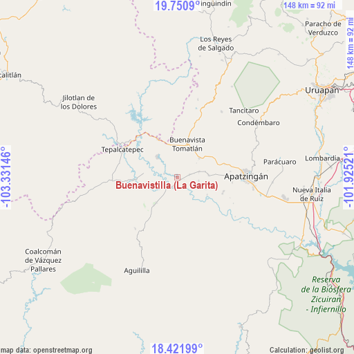
| Upper-left | 19.7509°, | -103.33146° |
| Center: | 19.08778°, | -102.62833° |
| Lower-right: | 18.42199°, | -101.92521° |
| Map W x H: | 147.8×147.8 km | = 91.8×91.8mi |
| max Lat: | 32.7° ⇑63.3% North |
| Buenavistilla (La Garita): | 19.08778° |
| min Lat: | ⇓36.7% South 14.53588° |
| min Long | Buenavistilla ( | max Long |
| -117.105° | -102.62833° | -86.73105° |
| W 15.4%⇐ | ⇒84.6% E |
Elevation
Elevation of Buenavistilla (La Garita) is 276 m = 906 ft, and this is 977.7 m = 3208 ft below average elevation for this country.
| Max E: |
3497 m = 11473 ft | 73.4% |
| Avg. | 1253.7 m = 4113 ft | |
| Buenavistilla (La Garita) | 276 m = 906 ft | |
Min E: |
-1 m = -3 ft | 26.6% |
See also: Mexico elevation on elevation.city.
Geographical zone
Buenavistilla (La Garita) is located in North Torrid zone (between Equator and Tropic of Cancer). Distance of this Northern Tropic circle is 483.6 km =300.5 mi to North.| Distance of | km | miles | from Buenavistilla (La Garita) |
|---|---|---|---|
| North Pole | 7884.7 | 4899.3 | to North |
| Arctic Circle | 5278.8 | 3280.1 | to North |
| Tropic Cancer | 483.6 | 300.5 | to North |
| Equator | 2122.4 | 1318.8 | to South |


Nearby cities:
15 places around Buenavistilla (La Garita): (largest is in red/bold)
• Bonifacio Moreno (El Aguaje)
13.8 km =8.6 mi,  219°
219°
• Buenavista Tomatlán
14.6 km =9.1 mi,  17°
17°
• Cenobio Moreno
13.1 km =8.1 mi,  85°
85°
• Dieciocho de Marzo
17.9 km =11.1 mi,  333°
333°
• División del Norte
1.8 km =1.1 mi,  110°
110°
• El Naranjo de Chila
18.6 km =11.6 mi,  177°
177°
• El Terrero
4.5 km =2.8 mi,  209°
209°
• Felipe Carrillo Puerto
11.9 km =7.4 mi,  314°
314°
• Loma Blanca
17.9 km =11.1 mi,  266°
266°
• Pinzándaro
9.5 km =5.9 mi,  75°
75°
• Puerta de Alambre (Ayacuato)
20.1 km =12.5 mi, 110°
• Punta del Agua
4.2 km =2.6 mi,  281°
281°
• Razo del Órgano (Veintiuno de Mayo)
13.1 km =8.1 mi, 113°
• Santa Ana Amatlán
12.3 km =7.6 mi,  48°
48°
• Vicente Guerrero
9.1 km =5.7 mi,  99°
99°
Sources, notices
• [Note1] Compared only with cities in Mexico existing in our database
• [Src1] Map data: © OpenStreetMap contributors (CC-BY-SA)
• [Src2] Other city data from geonames.org with taken over terms of usage.
• [Src3] Geographical zone / Annual Mean Temperature by Robert A. Rohde @ Wikipedia
