Loma Blanca geodata
Loma Blanca (Michoacán) is a populated place; located in Mexico in America/Mexico_City (GMT-6) time zone. With population of 629 people, there are 13762 cities with bigger population in this country. Compared to other cities in Mexico, 63.4% of cities are located further ↑North; 85.1% of cities are located further →East and 72.2% of cities have higher elevation than Loma Blanca. Note1


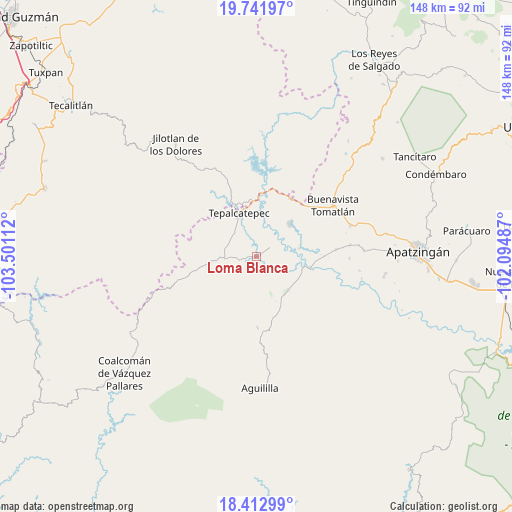
Loma Blanca GPS coordinates[2]
19° 4' 43.716" North, 102° 47' 52.764" West
| Map corner | latitude | longitude |
|---|---|---|
| Upper-left | 19.74197°, | -103.50112° |
| Center: | 19.07881°, | -102.79799° |
| Lower-right: | 18.41299°, | -102.09487° |
| Map W x H: | 147.8×147.8 km | = 91.8×91.8mi |
| max Lat: | 32.7° ⇑63.4% North |
| Loma Blanca: | 19.07881° |
| min Lat: | ⇓36.6% South 14.53588° |
| min Long | Loma Blanca | max Long |
| -117.105° | -102.79799° | -86.73105° |
| W 14.9%⇐ | ⇒85.1% E |
Elevation
Elevation of Loma Blanca is 322 m = 1056 ft, and this is 931.7 m = 3057 ft below average elevation for this country.
| Max E: |
3497 m = 11473 ft | 72.2% |
| Avg. | 1253.7 m = 4113 ft | |
| Loma Blanca | 322 m = 1056 ft | |
Min E: |
-1 m = -3 ft | 27.8% |
See also: Mexico elevation on elevation.city.
Geographical zone
Loma Blanca is located in North Torrid zone (between Equator and Tropic of Cancer). Distance of this Northern Tropic circle is 484.6 km =301.1 mi to North.| Distance of | km | miles | from Loma Blanca |
|---|---|---|---|
| North Pole | 7885.7 | 4899.9 | to North |
| Arctic Circle | 5279.8 | 3280.7 | to North |
| Tropic Cancer | 484.6 | 301.1 | to North |
| Equator | 2121.4 | 1318.2 | to South |


Nearby cities:
15 places around Loma Blanca: (largest is in red/bold)
• Bonifacio Moreno (El Aguaje)
13.3 km =8.3 mi,  136°
136°
• Buenavista Tomatlán
26.7 km =16.6 mi,  56°
56°
• Buenavistilla (La Garita)
17.9 km =11.1 mi,  86°
86°
• Dieciocho de Marzo
19.5 km =12.1 mi,  29°
29°
• División del Norte
19.5 km =12.1 mi, 88°
• El Naranjo de Chila
25.5 km =15.8 mi,  133°
133°
• El Terrero
15.9 km =9.9 mi,  100°
100°
• Felipe Carrillo Puerto
13.3 km =8.3 mi,  45°
45°
• Los Olivos
15.8 km =9.8 mi,  334°
334°
• Pinzándaro
27.2 km =16.9 mi,  82°
82°
• Punta del Agua
13.9 km =8.6 mi, 82°
• Rancho Nuevo
27.5 km =17.1 mi,  20°
20°
• Taixtan
13.2 km =8.2 mi,  253°
253°
• Tepalcatepec
13.1 km =8.1 mi,  335°
335°
• Vicente Guerrero
26.8 km =16.7 mi, 90°
Sources, notices
• [Note1] Compared only with cities in Mexico existing in our database
• [Src1] Map data: © OpenStreetMap contributors (CC-BY-SA)
• [Src2] Other city data from geonames.org with taken over terms of usage.
• [Src3] Geographical zone / Annual Mean Temperature by Robert A. Rohde @ Wikipedia
