Punta del Agua geodata
Punta del Agua (Michoacán) is a populated place; located in Mexico in America/Mexico_City (GMT-6) time zone. With population of 917 people, there are 9514 cities with bigger population in this country. Compared to other cities in Mexico, 63.2% of cities are located further ↑North; 84.7% of cities are located further →East and 73.4% of cities have higher elevation than Punta del Agua. Note1


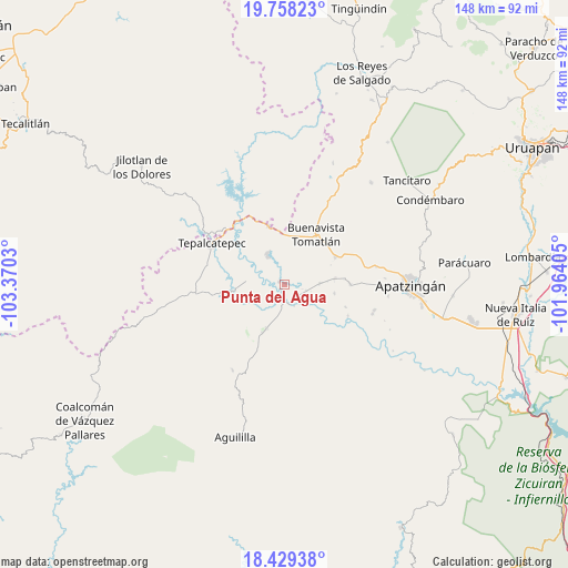
Punta del Agua GPS coordinates[2]
19° 5' 42.504" North, 102° 40' 1.812" West
| Map corner | latitude | longitude |
|---|---|---|
| Upper-left | 19.75823°, | -103.3703° |
| Center: | 19.09514°, | -102.66717° |
| Lower-right: | 18.42938°, | -101.96405° |
| Map W x H: | 147.8×147.8 km | = 91.8×91.8mi |
| max Lat: | 32.7° ⇑63.2% North |
| Punta del Agua: | 19.09514° |
| min Lat: | ⇓36.8% South 14.53588° |
| min Long | Punta del Agua | max Long |
| -117.105° | -102.66717° | -86.73105° |
| W 15.3%⇐ | ⇒84.7% E |
Elevation
Elevation of Punta del Agua is 275 m = 902 ft, and this is 978.7 m = 3211 ft below average elevation for this country.
| Max E: |
3497 m = 11473 ft | 73.4% |
| Avg. | 1253.7 m = 4113 ft | |
| Punta del Agua | 275 m = 902 ft | |
Min E: |
-1 m = -3 ft | 26.6% |
See also: Mexico elevation on elevation.city.
Geographical zone
Punta del Agua is located in North Torrid zone (between Equator and Tropic of Cancer). Distance of this Northern Tropic circle is 482.7 km =299.9 mi to North.| Distance of | km | miles | from Punta del Agua |
|---|---|---|---|
| North Pole | 7883.9 | 4898.8 | to North |
| Arctic Circle | 5278 | 3279.6 | to North |
| Tropic Cancer | 482.7 | 299.9 | to North |
| Equator | 2123.2 | 1319.3 | to South |


Nearby cities:
15 places around Punta del Agua: (largest is in red/bold)
• Bonifacio Moreno (El Aguaje)
12.4 km =7.7 mi,  201°
201°
• Buenavista Tomatlán
15.5 km =9.6 mi,  32°
32°
• Buenavistilla (La Garita)
4.2 km =2.6 mi,  101°
101°
• Cenobio Moreno
17.1 km =10.6 mi,  89°
89°
• Dieciocho de Marzo
15.7 km =9.8 mi,  345°
345°
• División del Norte
6 km =3.7 mi, 104°
• El Naranjo de Chila
19.9 km =12.4 mi,  166°
166°
• El Terrero
5.1 km =3.2 mi,  158°
158°
• Felipe Carrillo Puerto
8.7 km =5.4 mi,  330°
330°
• Loma Blanca
13.9 km =8.6 mi,  262°
262°
• Pinzándaro
13.4 km =8.3 mi,  83°
83°
• Razo del Órgano (Veintiuno de Mayo)
17.2 km =10.7 mi,  110°
110°
• Santa Ana Amatlán
15.2 km =9.4 mi,  61°
61°
• Tepalcatepec
21.7 km =13.5 mi,  298°
298°
• Vicente Guerrero
13.3 km =8.3 mi, 99°
Sources, notices
• [Note1] Compared only with cities in Mexico existing in our database
• [Src1] Map data: © OpenStreetMap contributors (CC-BY-SA)
• [Src2] Other city data from geonames.org with taken over terms of usage.
• [Src3] Geographical zone / Annual Mean Temperature by Robert A. Rohde @ Wikipedia
