Acatic geodata
Acatic (Jalisco) is a seat of a second-order administrative division; located in Mexico in America/Mexico_City (GMT-6) time zone. With population of 11,890 people, there are 807 cities with bigger population in this country. Compared to other cities in Mexico, 73% of cities are located further ↓South; 85.4% of cities are located further →East and 57.8% of cities have lower elevation than Acatic. Note1


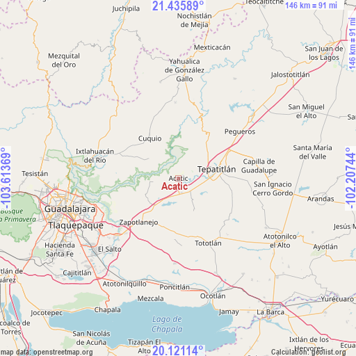
Acatic GPS coordinates[2]
20° 46' 47.82" North, 102° 54' 38.016" West
| Map corner | latitude | longitude |
|---|---|---|
| Upper-left | 21.43589°, | -103.61369° |
| Center: | 20.77995°, | -102.91056° |
| Lower-right: | 20.12114°, | -102.20744° |
| Map W x H: | 146.2×146.2 km | = 90.8×90.8mi |
| max Lat: | 32.7° ⇑27% North |
| Acatic: | 20.77995° |
| min Lat: | ⇓73% South 14.53588° |
| min Long | Acatic | max Long |
| -117.105° | -102.91056° | -86.73105° |
| W 14.6%⇐ | ⇒85.4% E |
Elevation
Elevation of Acatic is 1684 m = 5525 ft, and this is 430.3 m = 1412 ft above average elevation for this country.
| Max E: |
3497 m = 11473 ft | 42.2% |
| Acatic | 1684 m 5525 ft | |
| Avg. | 1253.7 m = 4113 ft | |
Min E: |
-1 m = -3 ft | 57.8% |
See also: Mexico elevation on elevation.city.
Geographical zone
Acatic is located in North Torrid zone (between Equator and Tropic of Cancer). Distance of this Northern Tropic circle is 295.4 km =183.6 mi to North.| Distance of | km | miles | from Acatic |
|---|---|---|---|
| North Pole | 7696.5 | 4782.4 | to North |
| Arctic Circle | 5090.7 | 3163.2 | to North |
| Tropic Cancer | 295.4 | 183.6 | to North |
| Equator | 2310.5 | 1435.7 | to South |


Nearby cities:
15 places around Acatic: (largest is in red/bold)
• Capilla de Milpillas
14.8 km =9.2 mi,  151°
151°
• Cuquío
20.7 km =12.9 mi,  323°
323°
• El Refugio
6.1 km =3.8 mi,  167°
167°
• La Esperanza
15.9 km =9.9 mi,  312°
312°
• La Loma (Loma de Enmedio)
17.9 km =11.1 mi,  83°
83°
• La Purísima
15.3 km =9.5 mi,  235°
235°
• Lázaro Cárdenas
21.8 km =13.5 mi,  327°
327°
• Mezcala
20.4 km =12.7 mi,  19°
19°
• Ramblas Chico
20.6 km =12.8 mi, 149°
• San Joaquín Zorrillos
20.8 km =12.9 mi,  211°
211°
• San José de las Flores
15.7 km =9.8 mi,  201°
201°
• Tecomatlán
18.2 km =11.3 mi,  179°
179°
• Tepatitlán de Morelos
15.8 km =9.8 mi,  74°
74°
• Teponahuasco
19.6 km =12.2 mi, 316°
• Tierras Coloradas
7.7 km =4.8 mi,  137°
137°
Sources, notices
• [Note1] Compared only with cities in Mexico existing in our database
• [Src1] Map data: © OpenStreetMap contributors (CC-BY-SA)
• [Src2] Other city data from geonames.org with taken over terms of usage.
• [Src3] Geographical zone / Annual Mean Temperature by Robert A. Rohde @ Wikipedia
