Mezcala geodata
Mezcala (Jalisco) is a populated place; located in Mexico in America/Mexico_City (GMT-6) time zone. With population of 2,085 people, there are 4188 cities with bigger population in this country. Compared to other cities in Mexico, 75.8% of cities are located further ↓South; 85.3% of cities are located further →East and 57.4% of cities have lower elevation than Mezcala. Note1


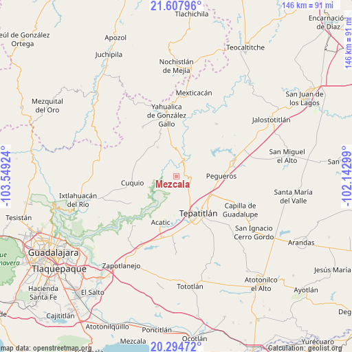
Mezcala GPS coordinates[2]
20° 57' 10.008" North, 102° 50' 45.996" West
| Map corner | latitude | longitude |
|---|---|---|
| Upper-left | 21.60796°, | -103.54924° |
| Center: | 20.95278°, | -102.84611° |
| Lower-right: | 20.29472°, | -102.14299° |
| Map W x H: | 146×146 km | = 90.7×90.7mi |
| max Lat: | 32.7° ⇑24.2% North |
| Mezcala: | 20.95278° |
| min Lat: | ⇓75.8% South 14.53588° |
| min Long | Mezcala | max Long |
| -117.105° | -102.84611° | -86.73105° |
| W 14.7%⇐ | ⇒85.3% E |
Elevation
Elevation of Mezcala is 1673 m = 5489 ft, and this is 419.3 m = 1376 ft above average elevation for this country.
| Max E: |
3497 m = 11473 ft | 42.6% |
| Mezcala | 1673 m 5489 ft | |
| Avg. | 1253.7 m = 4113 ft | |
Min E: |
-1 m = -3 ft | 57.4% |
See also: Mexico elevation on elevation.city.
Geographical zone
Mezcala is located in North Torrid zone (between Equator and Tropic of Cancer). Distance of this Northern Tropic circle is 276.2 km =171.6 mi to North.| Distance of | km | miles | from Mezcala |
|---|---|---|---|
| North Pole | 7677.3 | 4770.5 | to North |
| Arctic Circle | 5071.4 | 3151.2 | to North |
| Tropic Cancer | 276.2 | 171.6 | to North |
| Equator | 2329.7 | 1447.6 | to South |


Nearby cities:
15 places around Mezcala: (largest is in red/bold)
• Acatic
20.4 km =12.7 mi,  199°
199°
• Cuquío
19 km =11.8 mi,  262°
262°
• El Mirador
24 km =14.9 mi,  353°
353°
• El Zapote
18.3 km =11.4 mi,  13°
13°
• Huisquilco
24.8 km =15.4 mi,  325°
325°
• Juchitlán
23.5 km =14.6 mi,  294°
294°
• La Esperanza
20.2 km =12.6 mi,  245°
245°
• La Loma (Loma de Enmedio)
20.5 km =12.7 mi,  147°
147°
• Lázaro Cárdenas
18.3 km =11.4 mi,  267°
267°
• Manalisco
14.2 km =8.8 mi, 326°
• Pegueros
18.5 km =11.5 mi,  89°
89°
• San Gabriel
18.9 km =11.7 mi, 292°
• Tepatitlán de Morelos
17.4 km =10.8 mi, 150°
• Teponahuasco
20.7 km =12.9 mi, 256°
• Valle de Guadalupe
24.7 km =15.3 mi,  74°
74°
Sources, notices
• [Note1] Compared only with cities in Mexico existing in our database
• [Src1] Map data: © OpenStreetMap contributors (CC-BY-SA)
• [Src2] Other city data from geonames.org with taken over terms of usage.
• [Src3] Geographical zone / Annual Mean Temperature by Robert A. Rohde @ Wikipedia
