Teponahuasco geodata
Teponahuasco (Jalisco) is a populated place; located in Mexico in America/Mexico_City (GMT-6) time zone. With population of 949 people, there are 9178 cities with bigger population in this country. Compared to other cities in Mexico, 75% of cities are located further ↓South; 85.9% of cities are located further →East and 63.9% of cities have lower elevation than Teponahuasco. Note1


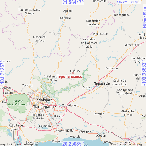
Teponahuasco GPS coordinates[2]
20° 54' 32.76" North, 103° 2' 21.984" West
| Map corner | latitude | longitude |
|---|---|---|
| Upper-left | 21.56447°, | -103.74257° |
| Center: | 20.9091°, | -103.03944° |
| Lower-right: | 20.25085°, | -102.33632° |
| Map W x H: | 146.1×146.1 km | = 90.8×90.8mi |
| max Lat: | 32.7° ⇑25% North |
| Teponahuasco: | 20.9091° |
| min Lat: | ⇓75% South 14.53588° |
| min Long | Teponahuasco | max Long |
| -117.105° | -103.03944° | -86.73105° |
| W 14.1%⇐ | ⇒85.9% E |
Elevation
Elevation of Teponahuasco is 1799 m = 5902 ft, and this is 545.3 m = 1789 ft above average elevation for this country.
| Max E: |
3497 m = 11473 ft | 36.1% |
| Teponahuasco | 1799 m 5902 ft | |
| Avg. | 1253.7 m = 4113 ft | |
Min E: |
-1 m = -3 ft | 63.9% |
See also: Mexico elevation on elevation.city.
Geographical zone
Teponahuasco is located in North Torrid zone (between Equator and Tropic of Cancer). Distance of this Northern Tropic circle is 281 km =174.6 mi to North.| Distance of | km | miles | from Teponahuasco |
|---|---|---|---|
| North Pole | 7682.2 | 4773.5 | to North |
| Arctic Circle | 5076.3 | 3154.3 | to North |
| Tropic Cancer | 281 | 174.6 | to North |
| Equator | 2324.9 | 1444.6 | to South |


Nearby cities:
15 places around Teponahuasco: (largest is in red/bold)
• Acatic
19.6 km =12.2 mi,  136°
136°
• Cuquío
2.7 km =1.7 mi,  27°
27°
• Ixtlahuacán del Río
21.5 km =13.4 mi,  256°
256°
• Juchitlán
14.7 km =9.1 mi,  354°
354°
• La Esperanza
3.9 km =2.4 mi,  153°
153°
• Las Cruces
14.8 km =9.2 mi,  328°
328°
• Lázaro Cárdenas
4.4 km =2.7 mi,  23°
23°
• Manalisco
20.7 km =12.9 mi,  36°
36°
• Mezcala
20.7 km =12.9 mi,  76°
76°
• Palos Altos
12.5 km =7.8 mi,  250°
250°
• San Antonio de los Vázquez
15 km =9.3 mi,  227°
227°
• San Gabriel
12.5 km =7.8 mi,  12°
12°
• San Juan del Monte
9.1 km =5.7 mi,  275°
275°
• Tacotlán
18.5 km =11.5 mi,  237°
237°
• Trejos
20.8 km =12.9 mi, 232°
Sources, notices
• [Note1] Compared only with cities in Mexico existing in our database
• [Src1] Map data: © OpenStreetMap contributors (CC-BY-SA)
• [Src2] Other city data from geonames.org with taken over terms of usage.
• [Src3] Geographical zone / Annual Mean Temperature by Robert A. Rohde @ Wikipedia
