Matamoros los Hoyos geodata
Matamoros los Hoyos (Jalisco) is a populated place; located in Mexico in America/Mexico_City (GMT-6) time zone. With population of 608 people, there are 14173 cities with bigger population in this country. Compared to other cities in Mexico, 83.2% of cities are located further ↓South; 81.1% of cities are located further →East and 73.1% of cities have lower elevation than Matamoros los Hoyos. Note1


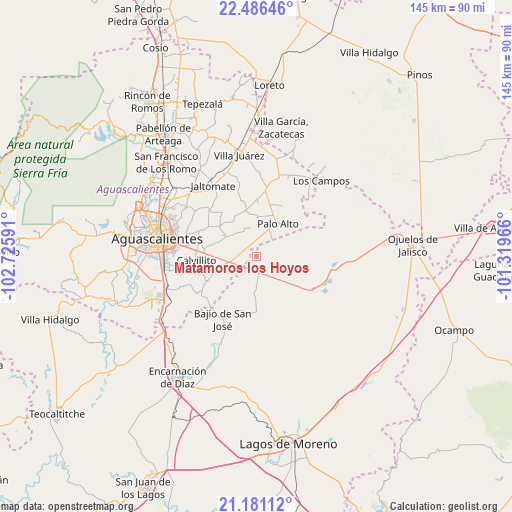
Matamoros los Hoyos GPS coordinates[2]
21° 50' 7.008" North, 102° 1' 22.008" West
| Map corner | latitude | longitude |
|---|---|---|
| Upper-left | 22.48646°, | -102.72591° |
| Center: | 21.83528°, | -102.02278° |
| Lower-right: | 21.18112°, | -101.31966° |
| Map W x H: | 145.1×145.1 km | = 90.2×90.2mi |
| max Lat: | 32.7° ⇑16.8% North |
| Matamoros los Hoyos: | 21.83528° |
| min Lat: | ⇓83.2% South 14.53588° |
| min Long | Matamoros los H | max Long |
| -117.105° | -102.02278° | -86.73105° |
| W 18.9%⇐ | ⇒81.1% E |
Elevation
Elevation of Matamoros los Hoyos is 1991 m = 6532 ft, and this is 737.3 m = 2419 ft above average elevation for this country.
| Max E: |
3497 m = 11473 ft | 26.9% |
| Matamoros los Hoyos | 1991 m 6532 ft | |
| Avg. | 1253.7 m = 4113 ft | |
Min E: |
-1 m = -3 ft | 73.1% |
See also: Mexico elevation on elevation.city.
Geographical zone
Matamoros los Hoyos is located in North Torrid zone (between Equator and Tropic of Cancer). Distance of this Northern Tropic circle is 178.1 km =110.7 mi to North.| Distance of | km | miles | from Matamoros los Hoyos |
|---|---|---|---|
| North Pole | 7579.2 | 4709.5 | to North |
| Arctic Circle | 4973.3 | 3090.3 | to North |
| Tropic Cancer | 178.1 | 110.7 | to North |
| Equator | 2427.9 | 1508.6 | to South |


Nearby cities:
15 places around Matamoros los Hoyos: (largest is in red/bold)
• Betulia
8.4 km =5.2 mi,  177°
177°
• Cuautitlán
12.3 km =7.6 mi,  153°
153°
• El Retoño
14.8 km =9.2 mi,  271°
271°
• Francisco Sarabia (La Reforma)
14.9 km =9.3 mi,  1°
1°
• La Punta
8.8 km =5.5 mi,  107°
107°
• La Troje
16.9 km =10.5 mi,  133°
133°
• Las Güeras
15.7 km =9.8 mi,  215°
215°
• Licenciado Jesús Terán (El Muerto)
16.5 km =10.3 mi,  345°
345°
• Los Azulitos
6.1 km =3.8 mi,  78°
78°
• Los Conos
7.5 km =4.7 mi,  22°
22°
• Montoya
6.5 km =4 mi,  41°
41°
• Ojo de Agua de Crucitas
16.1 km =10 mi,  26°
26°
• Palo Alto
11 km =6.8 mi, 33°
• Santa Rosa (El Huizache)
11.1 km =6.9 mi, 0°
• Tacubaya
9 km =5.6 mi, 134°
Sources, notices
• [Note1] Compared only with cities in Mexico existing in our database
• [Src1] Map data: © OpenStreetMap contributors (CC-BY-SA)
• [Src2] Other city data from geonames.org with taken over terms of usage.
• [Src3] Geographical zone / Annual Mean Temperature by Robert A. Rohde @ Wikipedia
