La Yerba geodata
La Yerba (Nuevo León) is a populated place; located in Mexico in America/Monterrey (GMT-6) time zone. With population of 773 people, there are 11306 cities with bigger population in this country. Compared to other cities in Mexico, 89.8% of cities are located further ↓South; 69.3% of cities are located further →East and 60.9% of cities have lower elevation than La Yerba. Note1


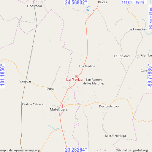
La Yerba GPS coordinates[2]
23° 55' 36.948" North, 100° 28' 56.892" West
| Map corner | latitude | longitude |
|---|---|---|
| Upper-left | 24.56802°, | -101.1856° |
| Center: | 23.92693°, | -100.48247° |
| Lower-right: | 23.28264°, | -99.77935° |
| Map W x H: | 142.9×142.9 km | = 88.8×88.8mi |
| max Lat: | 32.7° ⇑10.2% North |
| La Yerba: | 23.92693° |
| min Lat: | ⇓89.8% South 14.53588° |
| min Long | La Yerba | max Long |
| -117.105° | -100.48247° | -86.73105° |
| W 30.7%⇐ | ⇒69.3% E |
Elevation
Elevation of La Yerba is 1742 m = 5715 ft, and this is 488.3 m = 1602 ft above average elevation for this country.
| Max E: |
3497 m = 11473 ft | 39.1% |
| La Yerba | 1742 m 5715 ft | |
| Avg. | 1253.7 m = 4113 ft | |
Min E: |
-1 m = -3 ft | 60.9% |
See also: Mexico elevation on elevation.city.
Geographical zone
La Yerba is located in North temperate zone (between Tropic of Cancer and the Arctic Circle). Distance of this Northern Tropic circle is 54.5 km =33.9 mi to South.| Distance of | km | miles | from La Yerba |
|---|---|---|---|
| North Pole | 7346.6 | 4565 | to North |
| Arctic Circle | 4740.7 | 2945.7 | to North |
| Tropic Cancer | 54.5 | 33.9 | to South |
| Equator | 2660.4 | 1653.1 | to South |


Nearby cities:
15 places around La Yerba: (largest is in red/bold)
• Cedral
27.4 km =17 mi,  244°
244°
• Doctor Arroyo
41.7 km =25.9 mi,  132°
132°
• El Tepetate
59.3 km =36.8 mi,  297°
297°
• La Trinidad
47.1 km =29.3 mi,  66°
66°
• Las Palomas (Lajillas)
52.3 km =32.5 mi,  144°
144°
• Matehuala
35 km =21.7 mi,  207°
207°
• Medina
14 km =8.7 mi,  47°
47°
• Real de Catorce
48.8 km =30.3 mi, 237°
• Sacramento
39.9 km =24.8 mi, 209°
• San Cayetano de Vacas
5.5 km =3.4 mi, 67°
• San Isidro
30.5 km =19 mi,  257°
257°
• San Ramón de los Martínez
17.3 km =10.7 mi,  106°
106°
• Tanque Colorado
50.4 km =31.3 mi, 210°
• Vanegas
47.9 km =29.8 mi, 264°
• Villa de la Paz
36.3 km =22.6 mi,  219°
219°
Sources, notices
• [Note1] Compared only with cities in Mexico existing in our database
• [Src1] Map data: © OpenStreetMap contributors (CC-BY-SA)
• [Src2] Other city data from geonames.org with taken over terms of usage.
• [Src3] Geographical zone / Annual Mean Temperature by Robert A. Rohde @ Wikipedia
