La Trinidad geodata
La Trinidad (Nuevo León) is a populated place; located in Mexico in America/Monterrey (GMT-6) time zone. With population of 621 people, there are 13905 cities with bigger population in this country. Compared to other cities in Mexico, 90.2% of cities are located further ↓South; 64.7% of cities are located further →East and 54.9% of cities have lower elevation than La Trinidad. Note1


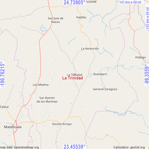
La Trinidad GPS coordinates[2]
24° 5' 55.788" North, 100° 3' 32.472" West
| Map corner | latitude | longitude |
|---|---|---|
| Upper-left | 24.73905°, | -100.76215° |
| Center: | 24.09883°, | -100.05902° |
| Lower-right: | 23.45539°, | -99.3559° |
| Map W x H: | 142.7×142.7 km | = 88.7×88.7mi |
| max Lat: | 32.7° ⇑9.8% North |
| La Trinidad: | 24.09883° |
| min Lat: | ⇓90.2% South 14.53588° |
| min Long | La Trinidad | max Long |
| -117.105° | -100.05902° | -86.73105° |
| W 35.3%⇐ | ⇒64.7% E |
Elevation
Elevation of La Trinidad is 1585 m = 5200 ft, and this is 331.3 m = 1087 ft above average elevation for this country.
| Max E: |
3497 m = 11473 ft | 45.1% |
| La Trinidad | 1585 m 5200 ft | |
| Avg. | 1253.7 m = 4113 ft | |
Min E: |
-1 m = -3 ft | 54.9% |
See also: Mexico elevation on elevation.city.
Geographical zone
La Trinidad is located in North temperate zone (between Tropic of Cancer and the Arctic Circle). Distance of this Northern Tropic circle is 73.6 km =45.7 mi to South.| Distance of | km | miles | from La Trinidad |
|---|---|---|---|
| North Pole | 7327.5 | 4553.1 | to North |
| Arctic Circle | 4721.6 | 2933.9 | to North |
| Tropic Cancer | 73.6 | 45.7 | to South |
| Equator | 2679.5 | 1665 | to South |


Nearby cities:
15 places around La Trinidad: (largest is in red/bold)
• Aramberri
24.5 km =15.2 mi,  89°
89°
• Doctor Arroyo
49 km =30.4 mi,  194°
194°
• General Zaragoza
32.3 km =20.1 mi,  115°
115°
• Hidalgo
65.1 km =40.5 mi,  75°
75°
• La Ascensión
29 km =18 mi,  30°
30°
• La Yerba
47.1 km =29.3 mi,  246°
246°
• Las Palomas (Lajillas)
62.7 km =39 mi, 191°
• Medina
34.1 km =21.2 mi, 253°
• Miquihuana
65.9 km =40.9 mi,  151°
151°
• Pablillo
55.2 km =34.3 mi,  6°
6°
• San Cayetano de Vacas
41.6 km =25.8 mi, 245°
• San José de Raíces
55.7 km =34.6 mi,  340°
340°
• San José del Llano
64 km =39.8 mi,  168°
168°
• San Ramón de los Martínez
35.7 km =22.2 mi,  227°
227°
• Villa Mainero
68.2 km =42.4 mi,  41°
41°
Sources, notices
• [Note1] Compared only with cities in Mexico existing in our database
• [Src1] Map data: © OpenStreetMap contributors (CC-BY-SA)
• [Src2] Other city data from geonames.org with taken over terms of usage.
• [Src3] Geographical zone / Annual Mean Temperature by Robert A. Rohde @ Wikipedia
