Sacramento geodata
Sacramento (San Luis Potosí) is a populated place; located in Mexico in America/Mexico_City (GMT-6) time zone. With population of 647 people, there are 13375 cities with bigger population in this country. Compared to other cities in Mexico, 89.1% of cities are located further ↓South; 70.9% of cities are located further →East and 56.5% of cities have lower elevation than Sacramento. Note1


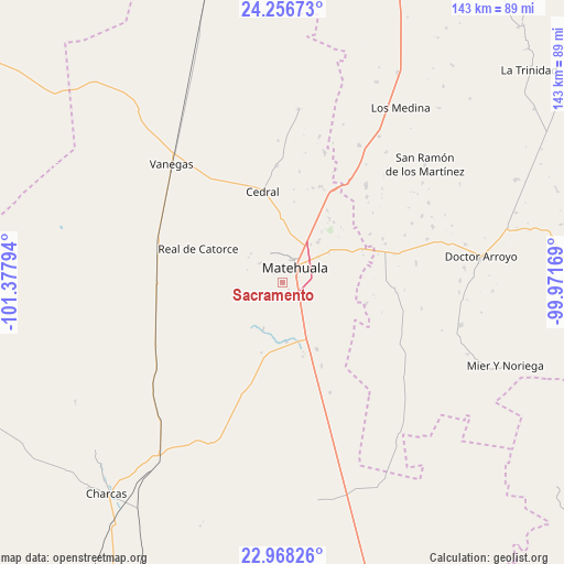
Sacramento GPS coordinates[2]
23° 36' 50.688" North, 100° 40' 29.316" West
| Map corner | latitude | longitude |
|---|---|---|
| Upper-left | 24.25673°, | -101.37794° |
| Center: | 23.61408°, | -100.67481° |
| Lower-right: | 22.96826°, | -99.97169° |
| Map W x H: | 143.3×143.3 km | = 89×89mi |
| max Lat: | 32.7° ⇑10.9% North |
| Sacramento: | 23.61408° |
| min Lat: | ⇓89.1% South 14.53588° |
| min Long | Sacramento | max Long |
| -117.105° | -100.67481° | -86.73105° |
| W 29.1%⇐ | ⇒70.9% E |
Elevation
Elevation of Sacramento is 1638 m = 5374 ft, and this is 384.3 m = 1261 ft above average elevation for this country.
| Max E: |
3497 m = 11473 ft | 43.5% |
| Sacramento | 1638 m 5374 ft | |
| Avg. | 1253.7 m = 4113 ft | |
Min E: |
-1 m = -3 ft | 56.5% |
See also: Mexico elevation on elevation.city.
Geographical zone
Sacramento is located in North temperate zone (between Tropic of Cancer and the Arctic Circle). Distance of this Northern Tropic circle is 19.7 km =12.2 mi to South.| Distance of | km | miles | from Sacramento |
|---|---|---|---|
| North Pole | 7381.4 | 4586.6 | to North |
| Arctic Circle | 4775.5 | 2967.4 | to North |
| Tropic Cancer | 19.7 | 12.2 | to South |
| Equator | 2625.6 | 1631.5 | to South |


Nearby cities:
15 places around Sacramento: (largest is in red/bold)
• Cedral
23.6 km =14.7 mi,  347°
347°
• Estación Wadley
32.1 km =19.9 mi,  269°
269°
• La Moreña
45.4 km =28.2 mi,  127°
127°
• La Yerba
39.9 km =24.8 mi,  29°
29°
• Matehuala
5 km =3.1 mi,  40°
40°
• Real de Catorce
23.2 km =14.4 mi,  291°
291°
• San Cayetano de Vacas
44.3 km =27.5 mi, 33°
• San Isidro
29.8 km =18.5 mi,  339°
339°
• San Ramón de los Martínez
46.9 km =29.1 mi,  50°
50°
• Santa Cruz
38.6 km =24 mi,  171°
171°
• Tanque Colorado
10.5 km =6.5 mi,  212°
212°
• Vanegas
41.2 km =25.6 mi,  316°
316°
• Villa de Guadalupe
28 km =17.4 mi,  197°
197°
• Villa de la Paz
7.9 km =4.9 mi,  331°
331°
• Zaragoza de Solís
43.5 km =27 mi, 201°
Sources, notices
• [Note1] Compared only with cities in Mexico existing in our database
• [Src1] Map data: © OpenStreetMap contributors (CC-BY-SA)
• [Src2] Other city data from geonames.org with taken over terms of usage.
• [Src3] Geographical zone / Annual Mean Temperature by Robert A. Rohde @ Wikipedia
