Vanegas geodata
Vanegas (San Luis Potosí) is a seat of a second-order administrative division; located in Mexico in America/Mexico_City (GMT-6) time zone. With population of 2,728 people, there are 3237 cities with bigger population in this country. Compared to other cities in Mexico, 89.7% of cities are located further ↓South; 73.1% of cities are located further →East and 60.7% of cities have lower elevation than Vanegas. Note1


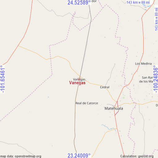
Vanegas GPS coordinates[2]
23° 53' 4.524" North, 100° 57' 5.328" West
| Map corner | latitude | longitude |
|---|---|---|
| Upper-left | 24.52589°, | -101.65461° |
| Center: | 23.88459°, | -100.95148° |
| Lower-right: | 23.24009°, | -100.24836° |
| Map W x H: | 143×143 km | = 88.9×88.9mi |
| max Lat: | 32.7° ⇑10.3% North |
| Vanegas: | 23.88459° |
| min Lat: | ⇓89.7% South 14.53588° |
| min Long | Vanegas | max Long |
| -117.105° | -100.95148° | -86.73105° |
| W 26.9%⇐ | ⇒73.1% E |
Elevation
Elevation of Vanegas is 1739 m = 5705 ft, and this is 485.3 m = 1592 ft above average elevation for this country.
| Max E: |
3497 m = 11473 ft | 39.3% |
| Vanegas | 1739 m 5705 ft | |
| Avg. | 1253.7 m = 4113 ft | |
Min E: |
-1 m = -3 ft | 60.7% |
See also: Mexico elevation on elevation.city.
Geographical zone
Vanegas is located in North temperate zone (between Tropic of Cancer and the Arctic Circle). Distance of this Northern Tropic circle is 49.8 km =30.9 mi to South.| Distance of | km | miles | from Vanegas |
|---|---|---|---|
| North Pole | 7351.3 | 4567.9 | to North |
| Arctic Circle | 4745.5 | 2948.7 | to North |
| Tropic Cancer | 49.8 | 30.9 | to South |
| Equator | 2655.7 | 1650.2 | to South |


Nearby cities:
15 places around Vanegas: (largest is in red/bold)
• Cedral
24.1 km =15 mi,  107°
107°
• El Tepetate
32.6 km =20.3 mi,  351°
351°
• Estación Wadley
30.6 km =19 mi,  187°
187°
• La Yerba
47.9 km =29.8 mi,  84°
84°
• Matehuala
40.9 km =25.4 mi,  129°
129°
• Medina
59.7 km =37.1 mi, 76°
• Real de Catorce
22.6 km =14 mi,  163°
163°
• Sacramento
41.2 km =25.6 mi,  136°
136°
• San Cayetano de Vacas
53.2 km =33.1 mi, 82°
• San Isidro
18.1 km =11.2 mi,  96°
96°
• Tanque Colorado
44.9 km =27.9 mi,  149°
149°
• Tanque Nuevo
55.6 km =34.5 mi,  358°
358°
• Villa de Guadalupe
60.1 km =37.3 mi, 160°
• Villa de la Paz
33.7 km =20.9 mi, 133°
• Zaragoza (La Vaca)
20.4 km =12.7 mi,  328°
328°
Sources, notices
• [Note1] Compared only with cities in Mexico existing in our database
• [Src1] Map data: © OpenStreetMap contributors (CC-BY-SA)
• [Src2] Other city data from geonames.org with taken over terms of usage.
• [Src3] Geographical zone / Annual Mean Temperature by Robert A. Rohde @ Wikipedia
