Carbajal geodata
Carbajal (Guanajuato) is a populated place; located in Mexico in America/Mexico_City (GMT-6) time zone. With population of 573 people, there are 14945 cities with bigger population in this country. Compared to other cities in Mexico, 77.3% of cities are located further ↓South; 67.1% of cities are located further →East and 81.1% of cities have lower elevation than Carbajal. Note1


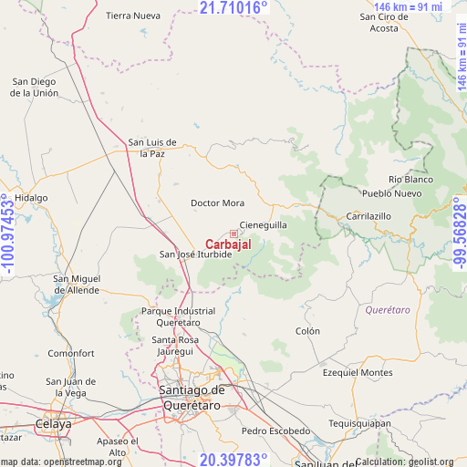
Carbajal GPS coordinates[2]
21° 3' 19.584" North, 100° 16' 17.04" West
| Map corner | latitude | longitude |
|---|---|---|
| Upper-left | 21.71016°, | -100.97453° |
| Center: | 21.05544°, | -100.2714° |
| Lower-right: | 20.39783°, | -99.56828° |
| Map W x H: | 145.9×145.9 km | = 90.7×90.7mi |
| max Lat: | 32.7° ⇑22.7% North |
| Carbajal: | 21.05544° |
| min Lat: | ⇓77.3% South 14.53588° |
| min Long | Carbajal | max Long |
| -117.105° | -100.2714° | -86.73105° |
| W 32.9%⇐ | ⇒67.1% E |
Elevation
Elevation of Carbajal is 2166 m = 7106 ft, and this is 912.3 m = 2993 ft above average elevation for this country.
| Max E: |
3497 m = 11473 ft | 18.9% |
| Carbajal | 2166 m 7106 ft | |
| Avg. | 1253.7 m = 4113 ft | |
Min E: |
-1 m = -3 ft | 81.1% |
See also: Mexico elevation on elevation.city.
Geographical zone
Carbajal is located in North Torrid zone (between Equator and Tropic of Cancer). Distance of this Northern Tropic circle is 264.8 km =164.5 mi to North.| Distance of | km | miles | from Carbajal |
|---|---|---|---|
| North Pole | 7665.9 | 4763.4 | to North |
| Arctic Circle | 5060 | 3144.1 | to North |
| Tropic Cancer | 264.8 | 164.5 | to North |
| Equator | 2341.1 | 1454.7 | to South |


Nearby cities:
15 places around Carbajal: (largest is in red/bold)
• Cano de San Isidro
5.4 km =3.4 mi,  69°
69°
• Cerro Colorado
6.7 km =4.2 mi,  37°
37°
• Cuesta de Peñones
4.8 km =3 mi,  48°
48°
• Derramadero de Charcas
7.1 km =4.4 mi,  327°
327°
• El Capulín
5.5 km =3.4 mi,  252°
252°
• El Picacho
8.7 km =5.4 mi,  76°
76°
• El Zapote
6.4 km =4 mi,  209°
209°
• La Ciénega
6 km =3.7 mi, 254°
• La Redonda
5.6 km =3.5 mi,  302°
302°
• Las Tuzas
7.5 km =4.7 mi,  197°
197°
• Miranda
6.8 km =4.2 mi,  291°
291°
• Ojo de Agua del Refugio
6.6 km =4.1 mi,  225°
225°
• Rincón de Cano
3.1 km =1.9 mi,  90°
90°
• Santa Anita
7.6 km =4.7 mi,  237°
237°
• Torrecitas
8.2 km =5.1 mi, 66°
Sources, notices
• [Note1] Compared only with cities in Mexico existing in our database
• [Src1] Map data: © OpenStreetMap contributors (CC-BY-SA)
• [Src2] Other city data from geonames.org with taken over terms of usage.
• [Src3] Geographical zone / Annual Mean Temperature by Robert A. Rohde @ Wikipedia
