La Redonda geodata
La Redonda (Guanajuato) is a populated place; located in Mexico in America/Mexico_City (GMT-6) time zone. With population of 548 people, there are 15532 cities with bigger population in this country. Compared to other cities in Mexico, 77.6% of cities are located further ↓South; 67.6% of cities are located further →East and 79% of cities have lower elevation than La Redonda. Note1


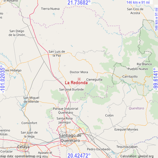
La Redonda GPS coordinates[2]
21° 4' 55.992" North, 100° 19' 1.992" West
| Map corner | latitude | longitude |
|---|---|---|
| Upper-left | 21.73682°, | -101.02035° |
| Center: | 21.08222°, | -100.31722° |
| Lower-right: | 20.42472°, | -99.6141° |
| Map W x H: | 145.9×145.9 km | = 90.7×90.7mi |
| max Lat: | 32.7° ⇑22.4% North |
| La Redonda: | 21.08222° |
| min Lat: | ⇓77.6% South 14.53588° |
| min Long | La Redonda | max Long |
| -117.105° | -100.31722° | -86.73105° |
| W 32.4%⇐ | ⇒67.6% E |
Elevation
Elevation of La Redonda is 2113 m = 6932 ft, and this is 859.3 m = 2819 ft above average elevation for this country.
| Max E: |
3497 m = 11473 ft | 21% |
| La Redonda | 2113 m 6932 ft | |
| Avg. | 1253.7 m = 4113 ft | |
Min E: |
-1 m = -3 ft | 79% |
See also: Mexico elevation on elevation.city.
Geographical zone
La Redonda is located in North Torrid zone (between Equator and Tropic of Cancer). Distance of this Northern Tropic circle is 261.8 km =162.7 mi to North.| Distance of | km | miles | from La Redonda |
|---|---|---|---|
| North Pole | 7662.9 | 4761.5 | to North |
| Arctic Circle | 5057.1 | 3142.3 | to North |
| Tropic Cancer | 261.8 | 162.7 | to North |
| Equator | 2344.1 | 1456.6 | to South |


Nearby cities:
15 places around La Redonda: (largest is in red/bold)
• Carbajal
5.6 km =3.5 mi,  122°
122°
• Cuesta de Peñones
8.4 km =5.2 mi,  88°
88°
• Derramadero de Charcas
3.1 km =1.9 mi,  17°
17°
• Doctor Mora
6.7 km =4.2 mi,  357°
357°
• El Capulín
4.7 km =2.9 mi,  186°
186°
• La Ciénega
4.7 km =2.9 mi, 193°
• La Noria
8 km =5 mi,  300°
300°
• La Reforma
8.3 km =5.2 mi,  246°
246°
• La Yerbabuena
6.6 km =4.1 mi,  214°
214°
• Miranda
1.6 km =1 mi, 254°
• Morisquilla
3.4 km =2.1 mi,  288°
288°
• Ojo de Agua del Refugio
7.6 km =4.7 mi,  179°
179°
• Rincón de Cano
8.4 km =5.2 mi,  111°
111°
• San Rafael
6.9 km =4.3 mi,  325°
325°
• Santa Anita
7.3 km =4.5 mi, 193°
Sources, notices
• [Note1] Compared only with cities in Mexico existing in our database
• [Src1] Map data: © OpenStreetMap contributors (CC-BY-SA)
• [Src2] Other city data from geonames.org with taken over terms of usage.
• [Src3] Geographical zone / Annual Mean Temperature by Robert A. Rohde @ Wikipedia
