La Ciénega geodata
La Ciénega (Guanajuato) is a populated place; located in Mexico in America/Mexico_City (GMT-6) time zone. With population of 694 people, there are 12543 cities with bigger population in this country. Compared to other cities in Mexico, 77.1% of cities are located further ↓South; 67.7% of cities are located further →East and 79.7% of cities have lower elevation than La Ciénega. Note1


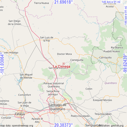
La Ciénega GPS coordinates[2]
21° 2' 29.04" North, 100° 19' 39.036" West
| Map corner | latitude | longitude |
|---|---|---|
| Upper-left | 21.69618°, | -101.03064° |
| Center: | 21.0414°, | -100.32751° |
| Lower-right: | 20.38373°, | -99.62439° |
| Map W x H: | 145.9×145.9 km | = 90.7×90.7mi |
| max Lat: | 32.7° ⇑22.9% North |
| La Ciénega: | 21.0414° |
| min Lat: | ⇓77.1% South 14.53588° |
| min Long | La Ciénega | max Long |
| -117.105° | -100.32751° | -86.73105° |
| W 32.3%⇐ | ⇒67.7% E |
Elevation
Elevation of La Ciénega is 2133 m = 6998 ft, and this is 879.3 m = 2885 ft above average elevation for this country.
| Max E: |
3497 m = 11473 ft | 20.3% |
| La Ciénega | 2133 m 6998 ft | |
| Avg. | 1253.7 m = 4113 ft | |
Min E: |
-1 m = -3 ft | 79.7% |
See also: Mexico elevation on elevation.city.
Geographical zone
La Ciénega is located in North Torrid zone (between Equator and Tropic of Cancer). Distance of this Northern Tropic circle is 266.3 km =165.5 mi to North.| Distance of | km | miles | from La Ciénega |
|---|---|---|---|
| North Pole | 7667.5 | 4764.4 | to North |
| Arctic Circle | 5061.6 | 3145.1 | to North |
| Tropic Cancer | 266.3 | 165.5 | to North |
| Equator | 2339.6 | 1453.8 | to South |


Nearby cities:
15 places around La Ciénega: (largest is in red/bold)
• Carbajal
6 km =3.7 mi,  74°
74°
• Derramadero de Charcas
7.8 km =4.8 mi,  14°
14°
• El Capulín
0.6 km =0.4 mi,  101°
101°
• El Pinito
8.6 km =5.3 mi,  236°
236°
• El Zapote
4.8 km =3 mi,  146°
146°
• La Redonda
4.7 km =2.9 mi, 13°
• La Reforma
6.7 km =4.2 mi,  280°
280°
• La Yerbabuena
2.8 km =1.7 mi,  251°
251°
• Las Tuzas
6.6 km =4.1 mi, 147°
• Miranda
4.1 km =2.5 mi,  353°
353°
• Morisquilla
6 km =3.7 mi,  339°
339°
• Ojo de Agua del Refugio
3.3 km =2.1 mi,  160°
160°
• Prados del Rosario
7.1 km =4.4 mi, 252°
• San José Iturbide
7.4 km =4.6 mi,  232°
232°
• Santa Anita
2.6 km =1.6 mi,  193°
193°
Sources, notices
• [Note1] Compared only with cities in Mexico existing in our database
• [Src1] Map data: © OpenStreetMap contributors (CC-BY-SA)
• [Src2] Other city data from geonames.org with taken over terms of usage.
• [Src3] Geographical zone / Annual Mean Temperature by Robert A. Rohde @ Wikipedia
