Cerro Prieto geodata
Cerro Prieto (Guanajuato) is a populated place; located in Mexico in America/Mexico_City (GMT-6) time zone. With population of 780 people, there are 11196 cities with bigger population in this country. Compared to other cities in Mexico, 68.2% of cities are located further ↓South; 75.8% of cities are located further →East and 59.1% of cities have lower elevation than Cerro Prieto. Note1


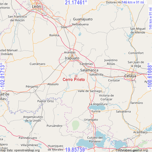
Cerro Prieto GPS coordinates[2]
20° 31' 3.072" North, 101° 18' 50.4" West
| Map corner | latitude | longitude |
|---|---|---|
| Upper-left | 21.17461°, | -102.01713° |
| Center: | 20.51752°, | -101.314° |
| Lower-right: | 19.85759°, | -100.61088° |
| Map W x H: | 146.4×146.4 km | = 91×91mi |
| max Lat: | 32.7° ⇑31.8% North |
| Cerro Prieto: | 20.51752° |
| min Lat: | ⇓68.2% South 14.53588° |
| min Long | Cerro Prieto | max Long |
| -117.105° | -101.314° | -86.73105° |
| W 24.2%⇐ | ⇒75.8% E |
Elevation
Elevation of Cerro Prieto is 1712 m = 5617 ft, and this is 458.3 m = 1504 ft above average elevation for this country.
| Max E: |
3497 m = 11473 ft | 40.9% |
| Cerro Prieto | 1712 m 5617 ft | |
| Avg. | 1253.7 m = 4113 ft | |
Min E: |
-1 m = -3 ft | 59.1% |
See also: Mexico elevation on elevation.city.
Geographical zone
Cerro Prieto is located in North Torrid zone (between Equator and Tropic of Cancer). Distance of this Northern Tropic circle is 324.6 km =201.7 mi to North.| Distance of | km | miles | from Cerro Prieto |
|---|---|---|---|
| North Pole | 7725.7 | 4800.5 | to North |
| Arctic Circle | 5119.8 | 3181.3 | to North |
| Tropic Cancer | 324.6 | 201.7 | to North |
| Equator | 2281.3 | 1417.5 | to South |


Nearby cities:
15 places around Cerro Prieto: (largest is in red/bold)
• El Tambor
2.5 km =1.6 mi,  150°
150°
• La Capilla
4.6 km =2.9 mi,  18°
18°
• La Soledad
3.4 km =2.1 mi,  345°
345°
• Labor de Valtierra
7.1 km =4.4 mi,  116°
116°
• Loma Pelada
6.4 km =4 mi, 18°
• Los Prietos
8.1 km =5 mi,  38°
38°
• Noria de Mosqueda
5.4 km =3.4 mi,  216°
216°
• Pueblo Nuevo
6.1 km =3.8 mi,  278°
278°
• Quiriceo
8.9 km =5.5 mi,  179°
179°
• San Diego Quiriceo
7.6 km =4.7 mi,  163°
163°
• San Felipe Quiriceo
8.7 km =5.4 mi, 162°
• San Guillermo
5.5 km =3.4 mi,  252°
252°
• San Nicolás Quiriceo
7.6 km =4.7 mi, 158°
• Santa Bárbara
5.9 km =3.7 mi, 218°
• Santo Domingo
8.9 km =5.5 mi,  91°
91°
Sources, notices
• [Note1] Compared only with cities in Mexico existing in our database
• [Src1] Map data: © OpenStreetMap contributors (CC-BY-SA)
• [Src2] Other city data from geonames.org with taken over terms of usage.
• [Src3] Geographical zone / Annual Mean Temperature by Robert A. Rohde @ Wikipedia
