La Soledad geodata
La Soledad (Guanajuato) is a populated place; located in Mexico in America/Mexico_City (GMT-6) time zone. With population of 558 people, there are 15286 cities with bigger population in this country. Compared to other cities in Mexico, 68.8% of cities are located further ↓South; 75.8% of cities are located further →East and 58.9% of cities have lower elevation than La Soledad. Note1


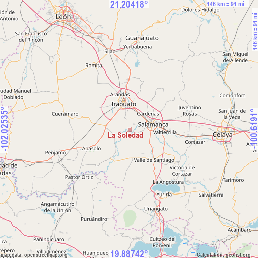
La Soledad GPS coordinates[2]
20° 32' 49.992" North, 101° 19' 19.992" West
| Map corner | latitude | longitude |
|---|---|---|
| Upper-left | 21.20418°, | -102.02535° |
| Center: | 20.54722°, | -101.32222° |
| Lower-right: | 19.88742°, | -100.6191° |
| Map W x H: | 146.4×146.4 km | = 91×91mi |
| max Lat: | 32.7° ⇑31.2% North |
| La Soledad: | 20.54722° |
| min Lat: | ⇓68.8% South 14.53588° |
| min Long | La Soledad | max Long |
| -117.105° | -101.32222° | -86.73105° |
| W 24.2%⇐ | ⇒75.8% E |
Elevation
Elevation of La Soledad is 1706 m = 5597 ft, and this is 452.3 m = 1484 ft above average elevation for this country.
| Max E: |
3497 m = 11473 ft | 41.1% |
| La Soledad | 1706 m 5597 ft | |
| Avg. | 1253.7 m = 4113 ft | |
Min E: |
-1 m = -3 ft | 58.9% |
See also: Mexico elevation on elevation.city.
Geographical zone
La Soledad is located in North Torrid zone (between Equator and Tropic of Cancer). Distance of this Northern Tropic circle is 321.3 km =199.6 mi to North.| Distance of | km | miles | from La Soledad |
|---|---|---|---|
| North Pole | 7722.4 | 4798.5 | to North |
| Arctic Circle | 5116.5 | 3179.2 | to North |
| Tropic Cancer | 321.3 | 199.6 | to North |
| Equator | 2284.6 | 1419.6 | to South |


Nearby cities:
15 places around La Soledad: (largest is in red/bold)
• Cerro Prieto
3.4 km =2.1 mi,  165°
165°
• Cuarta Brigada
9.4 km =5.8 mi,  27°
27°
• El Tambor
5.9 km =3.7 mi,  158°
158°
• La Capilla
2.5 km =1.6 mi,  65°
65°
• Labor de Valtierra
9.7 km =6 mi,  132°
132°
• Loma Pelada
4 km =2.5 mi,  46°
46°
• Los Prietos
6.6 km =4.1 mi,  62°
62°
• Noria de Mosqueda
8 km =5 mi,  197°
197°
• Pueblo Nuevo
5.7 km =3.5 mi,  244°
244°
• San Agustín el Alto (La Araña)
7.8 km =4.8 mi,  315°
315°
• San Guillermo
6.6 km =4.1 mi,  221°
221°
• San Roque
6.2 km =3.9 mi,  340°
340°
• Santa Bárbara
8.5 km =5.3 mi, 199°
• Tomelopitos
7.1 km =4.4 mi, 317°
• Villa de Guadalupe
6.5 km =4 mi,  289°
289°
Sources, notices
• [Note1] Compared only with cities in Mexico existing in our database
• [Src1] Map data: © OpenStreetMap contributors (CC-BY-SA)
• [Src2] Other city data from geonames.org with taken over terms of usage.
• [Src3] Geographical zone / Annual Mean Temperature by Robert A. Rohde @ Wikipedia
