San Miguel Epejan geodata
San Miguel Epejan (Michoacán) is a populated place; located in Mexico in America/Mexico_City (GMT-6) time zone. With population of 1,358 people, there are 6406 cities with bigger population in this country. Compared to other cities in Mexico, 58.5% of cities are located further ↓South; 79.8% of cities are located further →East and 63.8% of cities have lower elevation than San Miguel Epejan. Note1


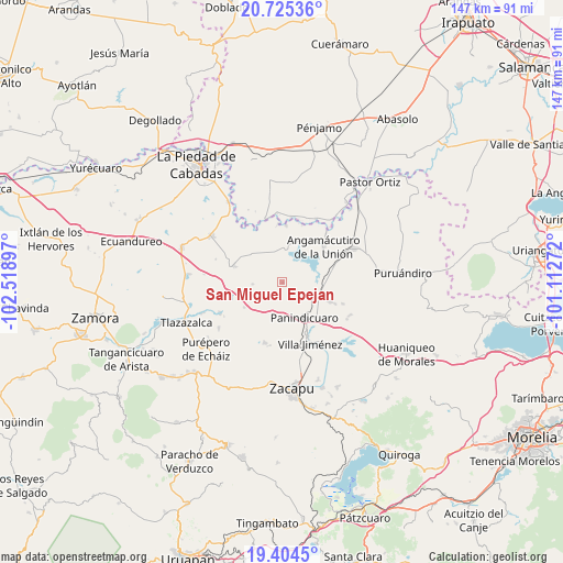
San Miguel Epejan GPS coordinates[2]
20° 3' 58.752" North, 101° 48' 57.024" West
| Map corner | latitude | longitude |
|---|---|---|
| Upper-left | 20.72536°, | -102.51897° |
| Center: | 20.06632°, | -101.81584° |
| Lower-right: | 19.4045°, | -101.11272° |
| Map W x H: | 146.9×146.9 km | = 91.3×91.3mi |
| max Lat: | 32.7° ⇑41.5% North |
| San Miguel Epejan: | 20.06632° |
| min Lat: | ⇓58.5% South 14.53588° |
| min Long | San Miguel Epej | max Long |
| -117.105° | -101.81584° | -86.73105° |
| W 20.2%⇐ | ⇒79.8% E |
Elevation
Elevation of San Miguel Epejan is 1797 m = 5896 ft, and this is 543.3 m = 1782 ft above average elevation for this country.
| Max E: |
3497 m = 11473 ft | 36.2% |
| San Miguel Epejan | 1797 m 5896 ft | |
| Avg. | 1253.7 m = 4113 ft | |
Min E: |
-1 m = -3 ft | 63.8% |
See also: Mexico elevation on elevation.city.
Geographical zone
San Miguel Epejan is located in North Torrid zone (between Equator and Tropic of Cancer). Distance of this Northern Tropic circle is 374.8 km =232.9 mi to North.| Distance of | km | miles | from San Miguel Epejan |
|---|---|---|---|
| North Pole | 7775.9 | 4831.7 | to North |
| Arctic Circle | 5170 | 3212.5 | to North |
| Tropic Cancer | 374.8 | 232.9 | to North |
| Equator | 2231.2 | 1386.4 | to South |


Nearby cities:
15 places around San Miguel Epejan: (largest is in red/bold)
• Agua Caliente
8.5 km =5.3 mi,  90°
90°
• Angamacutiro de la Unión
14.4 km =8.9 mi,  49°
49°
• Curimeo
13.6 km =8.5 mi,  112°
112°
• El Fresno de la Reforma
13.2 km =8.2 mi,  155°
155°
• J. Trinidad Regalado (La Colonia)
8.1 km =5 mi,  120°
120°
• La Estancia del Río
11.1 km =6.9 mi, 87°
• La Luz
11.3 km =7 mi,  312°
312°
• La Palma
8.4 km =5.2 mi,  69°
69°
• Panindícuaro
10.7 km =6.6 mi,  147°
147°
• Patambarillo
8.5 km =5.3 mi,  331°
331°
• Penjamillo de Degollado
13.1 km =8.1 mi,  288°
288°
• San Antonio Carupo
11.9 km =7.4 mi,  236°
236°
• San José de Rábago
13.6 km =8.5 mi,  322°
322°
• Tirimácuaro (Valanciana)
10.6 km =6.6 mi, 294°
• Ziquítaro
7.8 km =4.8 mi,  266°
266°
Sources, notices
• [Note1] Compared only with cities in Mexico existing in our database
• [Src1] Map data: © OpenStreetMap contributors (CC-BY-SA)
• [Src2] Other city data from geonames.org with taken over terms of usage.
• [Src3] Geographical zone / Annual Mean Temperature by Robert A. Rohde @ Wikipedia
