San Antonio Carupo geodata
San Antonio Carupo (Michoacán) is a populated place; located in Mexico in America/Mexico_City (GMT-6) time zone. With population of 523 people, there are 16139 cities with bigger population in this country. Compared to other cities in Mexico, 57.2% of cities are located further ↓South; 80.4% of cities are located further →East and 71.7% of cities have lower elevation than San Antonio Carupo. Note1


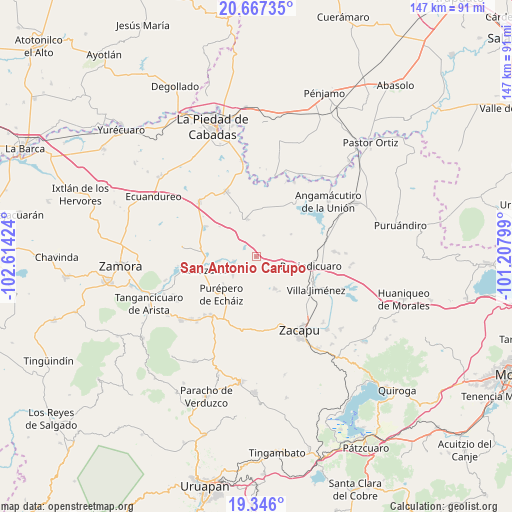
San Antonio Carupo GPS coordinates[2]
20° 0' 29.016" North, 101° 54' 39.996" West
| Map corner | latitude | longitude |
|---|---|---|
| Upper-left | 20.66735°, | -102.61424° |
| Center: | 20.00806°, | -101.91111° |
| Lower-right: | 19.346°, | -101.20799° |
| Map W x H: | 146.9×146.9 km | = 91.3×91.3mi |
| max Lat: | 32.7° ⇑42.8% North |
| San Antonio Carupo: | 20.00806° |
| min Lat: | ⇓57.2% South 14.53588° |
| min Long | San Antonio Car | max Long |
| -117.105° | -101.91111° | -86.73105° |
| W 19.6%⇐ | ⇒80.4% E |
Elevation
Elevation of San Antonio Carupo is 1962 m = 6437 ft, and this is 708.3 m = 2324 ft above average elevation for this country.
| Max E: |
3497 m = 11473 ft | 28.3% |
| San Antonio Carupo | 1962 m 6437 ft | |
| Avg. | 1253.7 m = 4113 ft | |
Min E: |
-1 m = -3 ft | 71.7% |
See also: Mexico elevation on elevation.city.
Geographical zone
San Antonio Carupo is located in North Torrid zone (between Equator and Tropic of Cancer). Distance of this Northern Tropic circle is 381.2 km =236.9 mi to North.| Distance of | km | miles | from San Antonio Carupo |
|---|---|---|---|
| North Pole | 7782.4 | 4835.8 | to North |
| Arctic Circle | 5176.5 | 3216.5 | to North |
| Tropic Cancer | 381.2 | 236.9 | to North |
| Equator | 2224.7 | 1382.4 | to South |


Nearby cities:
15 places around San Antonio Carupo: (largest is in red/bold)
• Acuitzeramo
6.4 km =4 mi,  256°
256°
• Caurio de Guadalupe
10.7 km =6.6 mi,  150°
150°
• Caurio de la Rinconada
11.9 km =7.4 mi, 147°
• El Fresno de la Reforma
16.3 km =10.1 mi,  110°
110°
• J. Trinidad Regalado (La Colonia)
17.1 km =10.6 mi,  82°
82°
• La Luz
14.3 km =8.9 mi,  6°
6°
• La Yerbabuena
11 km =6.8 mi, 263°
• Panindícuaro
15.9 km =9.9 mi,  99°
99°
• Patambarillo
15.2 km =9.4 mi,  22°
22°
• Penjamillo de Degollado
11 km =6.8 mi,  347°
347°
• Purépero de Echáiz
14.7 km =9.1 mi,  222°
222°
• San Miguel Epejan
11.9 km =7.4 mi,  56°
56°
• Tirimácuaro (Valanciana)
10.9 km =6.8 mi,  1°
1°
• Tlazazalca
15.9 km =9.9 mi,  254°
254°
• Ziquítaro
6.4 km =4 mi, 19°
Sources, notices
• [Note1] Compared only with cities in Mexico existing in our database
• [Src1] Map data: © OpenStreetMap contributors (CC-BY-SA)
• [Src2] Other city data from geonames.org with taken over terms of usage.
• [Src3] Geographical zone / Annual Mean Temperature by Robert A. Rohde @ Wikipedia
