San Miguel geodata
San Miguel (Michoacán) is a populated place; located in Mexico in America/Mexico_City (GMT-6) time zone. With population of 542 people, there are 15673 cities with bigger population in this country. Compared to other cities in Mexico, 57.8% of cities are located further ↓South; 78.6% of cities are located further →East and 70.8% of cities have lower elevation than San Miguel. Note1


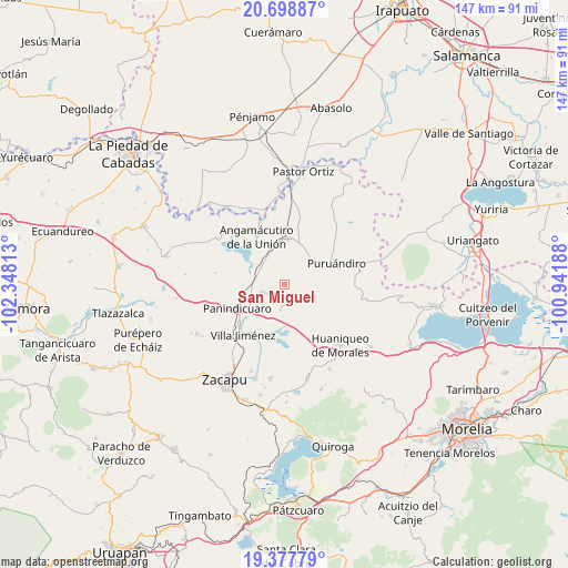
San Miguel GPS coordinates[2]
20° 2' 22.992" North, 101° 38' 42" West
| Map corner | latitude | longitude |
|---|---|---|
| Upper-left | 20.69887°, | -102.34813° |
| Center: | 20.03972°, | -101.645° |
| Lower-right: | 19.37779°, | -100.94188° |
| Map W x H: | 146.9×146.9 km | = 91.3×91.3mi |
| max Lat: | 32.7° ⇑42.2% North |
| San Miguel: | 20.03972° |
| min Lat: | ⇓57.8% South 14.53588° |
| min Long | San Miguel | max Long |
| -117.105° | -101.645° | -86.73105° |
| W 21.4%⇐ | ⇒78.6% E |
Elevation
Elevation of San Miguel is 1941 m = 6368 ft, and this is 687.3 m = 2255 ft above average elevation for this country.
| Max E: |
3497 m = 11473 ft | 29.2% |
| San Miguel | 1941 m 6368 ft | |
| Avg. | 1253.7 m = 4113 ft | |
Min E: |
-1 m = -3 ft | 70.8% |
See also: Mexico elevation on elevation.city.
Geographical zone
San Miguel is located in North Torrid zone (between Equator and Tropic of Cancer). Distance of this Northern Tropic circle is 377.7 km =234.7 mi to North.| Distance of | km | miles | from San Miguel |
|---|---|---|---|
| North Pole | 7778.9 | 4833.6 | to North |
| Arctic Circle | 5173 | 3214.4 | to North |
| Tropic Cancer | 377.7 | 234.7 | to North |
| Equator | 2228.2 | 1384.5 | to South |


Nearby cities:
15 places around San Miguel: (largest is in red/bold)
• Agua Caliente
9.8 km =6.1 mi,  286°
286°
• Curimeo
5.7 km =3.5 mi,  247°
247°
• El Maluco
12.1 km =7.5 mi,  344°
344°
• Galeana
7.7 km =4.8 mi,  93°
93°
• J. Trinidad Regalado (La Colonia)
10.9 km =6.8 mi,  263°
263°
• Janamuato
9.1 km =5.7 mi,  43°
43°
• La Estancia del Río
7.5 km =4.7 mi,  296°
296°
• La Luz
6.6 km =4.1 mi,  188°
188°
• La Palma
11.5 km =7.1 mi, 300°
• Nuevo Progreso (Casas Viejas)
1.2 km =0.7 mi,  328°
328°
• Sabino Buenavista
7.2 km =4.5 mi,  54°
54°
• San Lorenzo
5.6 km =3.5 mi,  180°
180°
• Urequío
8.3 km =5.2 mi,  213°
213°
• Ururuta
4 km =2.5 mi,  82°
82°
• Villachuato
12.1 km =7.5 mi,  5°
5°
Sources, notices
• [Note1] Compared only with cities in Mexico existing in our database
• [Src1] Map data: © OpenStreetMap contributors (CC-BY-SA)
• [Src2] Other city data from geonames.org with taken over terms of usage.
• [Src3] Geographical zone / Annual Mean Temperature by Robert A. Rohde @ Wikipedia
