Almoloya geodata
Almoloya (Guerrero) is a populated place; located in Mexico in America/Mexico_City (GMT-6) time zone. With population of 869 people, there are 10053 cities with bigger population in this country. Compared to other cities in Mexico, 74.2% of cities are located further ↑North; 66.2% of cities are located further →East and 67.6% of cities have higher elevation than Almoloya. Note1


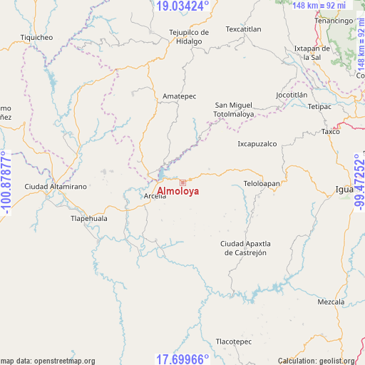
Almoloya GPS coordinates[2]
18° 22' 5.664" North, 100° 10' 32.304" West
| Map corner | latitude | longitude |
|---|---|---|
| Upper-left | 19.03424°, | -100.87877° |
| Center: | 18.36824°, | -100.17564° |
| Lower-right: | 17.69966°, | -99.47252° |
| Map W x H: | 148.4×148.4 km | = 92.2×92.2mi |
| max Lat: | 32.7° ⇑74.2% North |
| Almoloya: | 18.36824° |
| min Lat: | ⇓25.8% South 14.53588° |
| min Long | Almoloya | max Long |
| -117.105° | -100.17564° | -86.73105° |
| W 33.8%⇐ | ⇒66.2% E |
Elevation
Elevation of Almoloya is 548 m = 1798 ft, and this is 705.7 m = 2315 ft below average elevation for this country.
| Max E: |
3497 m = 11473 ft | 67.6% |
| Avg. | 1253.7 m = 4113 ft | |
| Almoloya | 548 m = 1798 ft | |
Min E: |
-1 m = -3 ft | 32.4% |
See also: Mexico elevation on elevation.city.
Geographical zone
Almoloya is located in North Torrid zone (between Equator and Tropic of Cancer). Distance of this Northern Tropic circle is 563.6 km =350.2 mi to North.| Distance of | km | miles | from Almoloya |
|---|---|---|---|
| North Pole | 7964.7 | 4949 | to North |
| Arctic Circle | 5358.8 | 3329.8 | to North |
| Tropic Cancer | 563.6 | 350.2 | to North |
| Equator | 2042.4 | 1269.1 | to South |


Nearby cities:
15 places around Almoloya: (largest is in red/bold)
• Acapetlahuaya
12.3 km =7.6 mi,  62°
62°
• Arcelia
12.5 km =7.8 mi,  243°
243°
• Colonia Emperador Cuauhtémoc
14.9 km =9.3 mi, 236°
• Cuauhlotitlán
16.3 km =10.1 mi,  261°
261°
• El Escondido
21.8 km =13.5 mi,  221°
221°
• El Naranjo
12.2 km =7.6 mi,  277°
277°
• El Temblor
14.4 km =8.9 mi, 280°
• Lídice
19.8 km =12.3 mi, 56°
• Nuevo Copaltepec
11.9 km =7.4 mi, 278°
• Palos Altos
10.4 km =6.5 mi,  271°
271°
• Reforma de Lázaro Cárdenas (El Aterrizaje)
14.3 km =8.9 mi,  234°
234°
• Rincón Grande
20.2 km =12.6 mi,  295°
295°
• San Antonio del Rosario
14.5 km =9 mi, 284°
• Santo Niño
18.1 km =11.2 mi, 239°
• Totoltepec
17.5 km =10.9 mi,  125°
125°
Sources, notices
• [Note1] Compared only with cities in Mexico existing in our database
• [Src1] Map data: © OpenStreetMap contributors (CC-BY-SA)
• [Src2] Other city data from geonames.org with taken over terms of usage.
• [Src3] Geographical zone / Annual Mean Temperature by Robert A. Rohde @ Wikipedia
