Pujal-Coy geodata
Pujal-Coy (San Luis Potosí) is a populated place; located in Mexico in America/Mexico_City (GMT-6) time zone. With population of 3,346 people, there are 2716 cities with bigger population in this country. Compared to other cities in Mexico, 85.1% of cities are located further ↓South; 57.2% of cities are located further ←West and 87% of cities have higher elevation than Pujal-Coy. Note1


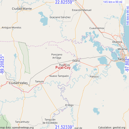
Pujal-Coy GPS coordinates[2]
22° 10' 33.6" North, 98° 30' 18.432" West
| Map corner | latitude | longitude |
|---|---|---|
| Upper-left | 22.82559°, | -99.20825° |
| Center: | 22.176°, | -98.50512° |
| Lower-right: | 21.52339°, | -97.802° |
| Map W x H: | 144.8×144.8 km | = 90×90mi |
| max Lat: | 32.7° ⇑14.9% North |
| Pujal-Coy: | 22.176° |
| min Lat: | ⇓85.1% South 14.53588° |
| min Long | Pujal-Coy | max Long |
| -117.105° | -98.50512° | -86.73105° |
| W 57.2%⇐ | ⇒42.8% E |
Elevation
Elevation of Pujal-Coy is 34 m = 112 ft, and this is 1219.7 m = 4002 ft below average elevation for this country.
| Max E: |
3497 m = 11473 ft | 87% |
| Avg. | 1253.7 m = 4113 ft | |
| Pujal-Coy | 34 m = 112 ft | |
Min E: |
-1 m = -3 ft | 13% |
See also: Mexico elevation on elevation.city.
Geographical zone
Pujal-Coy is located in North Torrid zone (between Equator and Tropic of Cancer). Distance of this Northern Tropic circle is 140.2 km =87.1 mi to North.| Distance of | km | miles | from Pujal-Coy |
|---|---|---|---|
| North Pole | 7541.3 | 4685.9 | to North |
| Arctic Circle | 4935.4 | 3066.7 | to North |
| Tropic Cancer | 140.2 | 87.1 | to North |
| Equator | 2465.7 | 1532.1 | to South |


Nearby cities:
15 places around Pujal-Coy: (largest is in red/bold)
• Aurelio Manrique
19.5 km =12.1 mi,  309°
309°
• Chijol Diecisiete
25.2 km =15.7 mi,  70°
70°
• Colonia Piloto
23.2 km =14.4 mi,  38°
38°
• Ejido la Reforma
18.1 km =11.2 mi,  166°
166°
• Ejido los Huastecos
28.4 km =17.6 mi,  211°
211°
• El Centinela
19.1 km =11.9 mi,  233°
233°
• Estación Velazco
6.3 km =3.9 mi,  286°
286°
• Guayalejo
23.1 km =14.4 mi,  5°
5°
• Nuevo Tampaón
14.1 km =8.8 mi, 206°
• Nuevo Tantoán
28.6 km =17.8 mi,  346°
346°
• Oviedo
18.1 km =11.2 mi,  143°
143°
• Plan de Iguala
16.1 km =10 mi,  164°
164°
• Ponciano Arriaga
13 km =8.1 mi,  317°
317°
• Santa Martha
27.8 km =17.3 mi, 311°
• Ébano
14 km =8.7 mi, 70°
Sources, notices
• [Note1] Compared only with cities in Mexico existing in our database
• [Src1] Map data: © OpenStreetMap contributors (CC-BY-SA)
• [Src2] Other city data from geonames.org with taken over terms of usage.
• [Src3] Geographical zone / Annual Mean Temperature by Robert A. Rohde @ Wikipedia
