Ejido la Reforma geodata
Ejido la Reforma (San Luis Potosí) is a populated place; located in Mexico in America/Mexico_City (GMT-6) time zone. With population of 891 people, there are 9789 cities with bigger population in this country. Compared to other cities in Mexico, 84.3% of cities are located further ↓South; 57.7% of cities are located further ←West and 90.8% of cities have higher elevation than Ejido la Reforma. Note1


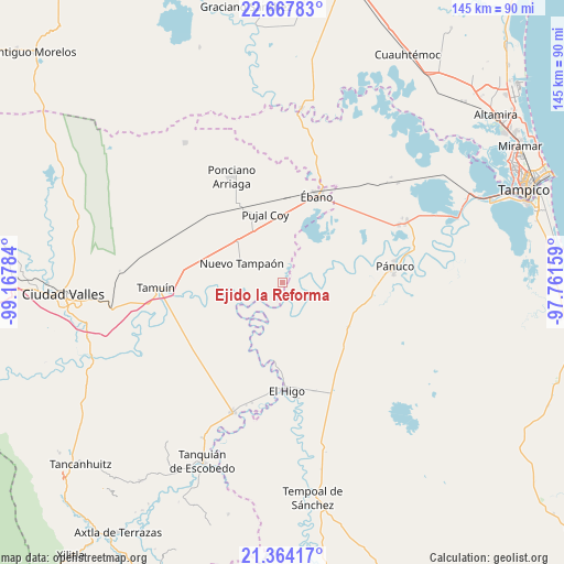
Ejido la Reforma GPS coordinates[2]
22° 1' 3" North, 98° 27' 52.956" West
| Map corner | latitude | longitude |
|---|---|---|
| Upper-left | 22.66783°, | -99.16784° |
| Center: | 22.0175°, | -98.46471° |
| Lower-right: | 21.36417°, | -97.76159° |
| Map W x H: | 145×145 km | = 90.1×90.1mi |
| max Lat: | 32.7° ⇑15.7% North |
| Ejido la Reforma: | 22.0175° |
| min Lat: | ⇓84.3% South 14.53588° |
| min Long | Ejido la Reform | max Long |
| -117.105° | -98.46471° | -86.73105° |
| W 57.7%⇐ | ⇒42.3% E |
Elevation
Elevation of Ejido la Reforma is 22 m = 72 ft, and this is 1231.7 m = 4041 ft below average elevation for this country.
| Max E: |
3497 m = 11473 ft | 90.8% |
| Avg. | 1253.7 m = 4113 ft | |
| Ejido la Reforma | 22 m = 72 ft | |
Min E: |
-1 m = -3 ft | 9.2% |
See also: Mexico elevation on elevation.city.
Geographical zone
Ejido la Reforma is located in North Torrid zone (between Equator and Tropic of Cancer). Distance of this Northern Tropic circle is 157.8 km =98.1 mi to North.| Distance of | km | miles | from Ejido la Reforma |
|---|---|---|---|
| North Pole | 7558.9 | 4696.9 | to North |
| Arctic Circle | 4953.1 | 3077.7 | to North |
| Tropic Cancer | 157.8 | 98.1 | to North |
| Equator | 2448.1 | 1521.2 | to South |


Nearby cities:
15 places around Ejido la Reforma: (largest is in red/bold)
• Ejido los Huastecos
20.2 km =12.6 mi,  251°
251°
• El Centinela
20.5 km =12.7 mi,  287°
287°
• El Chote
22.8 km =14.2 mi,  180°
180°
• El Higo
27.9 km =17.3 mi, 177°
• El Molino
20.5 km =12.7 mi,  123°
123°
• El Pueblito
24.2 km =15 mi, 178°
• Estación Velazco
21.9 km =13.6 mi,  332°
332°
• Nuevo Ahuacatitla
21.6 km =13.4 mi,  241°
241°
• Nuevo Tampaón
11.5 km =7.1 mi,  295°
295°
• Oviedo
7.3 km =4.5 mi,  65°
65°
• Plan de Iguala
2.1 km =1.3 mi,  0°
0°
• Pujal-Coy
18.1 km =11.2 mi,  346°
346°
• Pánuco
29.1 km =18.1 mi,  82°
82°
• Reventadero
29.3 km =18.2 mi, 67°
• Ébano
24.1 km =15 mi,  22°
22°
Sources, notices
• [Note1] Compared only with cities in Mexico existing in our database
• [Src1] Map data: © OpenStreetMap contributors (CC-BY-SA)
• [Src2] Other city data from geonames.org with taken over terms of usage.
• [Src3] Geographical zone / Annual Mean Temperature by Robert A. Rohde @ Wikipedia
