Nuevo Tampaón geodata
Nuevo Tampaón (San Luis Potosí) is a populated place; located in Mexico in America/Mexico_City (GMT-6) time zone. With population of 3,321 people, there are 2742 cities with bigger population in this country. Compared to other cities in Mexico, 84.5% of cities are located further ↓South; 56.5% of cities are located further ←West and 85.5% of cities have higher elevation than Nuevo Tampaón. Note1


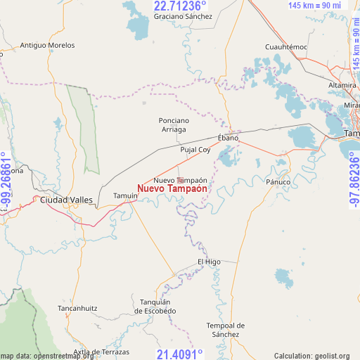
Nuevo Tampaón GPS coordinates[2]
22° 3' 44.028" North, 98° 33' 55.728" West
| Map corner | latitude | longitude |
|---|---|---|
| Upper-left | 22.71236°, | -99.26861° |
| Center: | 22.06223°, | -98.56548° |
| Lower-right: | 21.4091°, | -97.86236° |
| Map W x H: | 144.9×144.9 km | = 90×90mi |
| max Lat: | 32.7° ⇑15.5% North |
| Nuevo Tampaón: | 22.06223° |
| min Lat: | ⇓84.5% South 14.53588° |
| min Long | Nuevo Tampaón | max Long |
| -117.105° | -98.56548° | -86.73105° |
| W 56.5%⇐ | ⇒43.5% E |
Elevation
Elevation of Nuevo Tampaón is 41 m = 135 ft, and this is 1212.7 m = 3979 ft below average elevation for this country.
| Max E: |
3497 m = 11473 ft | 85.5% |
| Avg. | 1253.7 m = 4113 ft | |
| Nuevo Tampaón | 41 m = 135 ft | |
Min E: |
-1 m = -3 ft | 14.5% |
See also: Mexico elevation on elevation.city.
Geographical zone
Nuevo Tampaón is located in North Torrid zone (between Equator and Tropic of Cancer). Distance of this Northern Tropic circle is 152.8 km =94.9 mi to North.| Distance of | km | miles | from Nuevo Tampaón |
|---|---|---|---|
| North Pole | 7554 | 4693.8 | to North |
| Arctic Circle | 4948.1 | 3074.6 | to North |
| Tropic Cancer | 152.8 | 94.9 | to North |
| Equator | 2453.1 | 1524.3 | to South |


Nearby cities:
15 places around Nuevo Tampaón: (largest is in red/bold)
• Antiguo Tamuín
22.1 km =13.7 mi,  249°
249°
• Aurelio Manrique
26.5 km =16.5 mi,  340°
340°
• Ejido la Reforma
11.5 km =7.1 mi,  115°
115°
• Ejido los Huastecos
14.4 km =8.9 mi,  217°
217°
• El Centinela
9.2 km =5.7 mi,  277°
277°
• Estación Tamuín
25.4 km =15.8 mi,  273°
273°
• Estación Velazco
14.5 km =9 mi,  0°
0°
• La Fortaleza
26.1 km =16.2 mi, 246°
• Nuevo Ahuacatitla
17.5 km =10.9 mi,  209°
209°
• Oviedo
17.1 km =10.6 mi,  96°
96°
• Plan de Iguala
10.8 km =6.7 mi,  105°
105°
• Ponciano Arriaga
22.4 km =13.9 mi,  353°
353°
• Pujal-Coy
14.1 km =8.8 mi,  26°
26°
• Tamuín
23 km =14.3 mi, 254°
• Ébano
26 km =16.2 mi,  48°
48°
Sources, notices
• [Note1] Compared only with cities in Mexico existing in our database
• [Src1] Map data: © OpenStreetMap contributors (CC-BY-SA)
• [Src2] Other city data from geonames.org with taken over terms of usage.
• [Src3] Geographical zone / Annual Mean Temperature by Robert A. Rohde @ Wikipedia
