El Palmar geodata
El Palmar (Veracruz) is a populated place; located in Mexico in America/Mexico_City (GMT-6) time zone. With population of 583 people, there are 14713 cities with bigger population in this country. Compared to other cities in Mexico, 70.1% of cities are located further ↓South; 70.3% of cities are located further ←West and 85.3% of cities have higher elevation than El Palmar. Note1


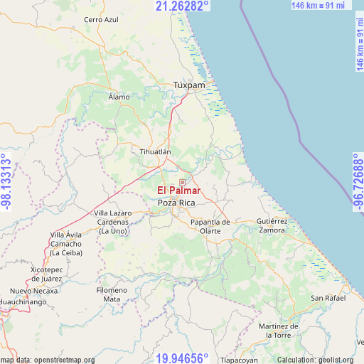
El Palmar GPS coordinates[2]
20° 36' 21.996" North, 97° 25' 48" West
| Map corner | latitude | longitude |
|---|---|---|
| Upper-left | 21.26282°, | -98.13313° |
| Center: | 20.60611°, | -97.43° |
| Lower-right: | 19.94656°, | -96.72688° |
| Map W x H: | 146.4×146.4 km | = 91×91mi |
| max Lat: | 32.7° ⇑29.9% North |
| El Palmar: | 20.60611° |
| min Lat: | ⇓70.1% South 14.53588° |
| min Long | El Palmar | max Long |
| -117.105° | -97.43° | -86.73105° |
| W 70.3%⇐ | ⇒29.7% E |
Elevation
Elevation of El Palmar is 42 m = 138 ft, and this is 1211.7 m = 3975 ft below average elevation for this country.
| Max E: |
3497 m = 11473 ft | 85.3% |
| Avg. | 1253.7 m = 4113 ft | |
| El Palmar | 42 m = 138 ft | |
Min E: |
-1 m = -3 ft | 14.7% |
See also: Mexico elevation on elevation.city.
Geographical zone
El Palmar is located in North Torrid zone (between Equator and Tropic of Cancer). Distance of this Northern Tropic circle is 314.7 km =195.5 mi to North.| Distance of | km | miles | from El Palmar |
|---|---|---|---|
| North Pole | 7715.9 | 4794.4 | to North |
| Arctic Circle | 5110 | 3175.2 | to North |
| Tropic Cancer | 314.7 | 195.5 | to North |
| Equator | 2291.2 | 1423.7 | to South |


Nearby cities:
15 places around El Palmar: (largest is in red/bold)
• Colonia las Arboledas
1.7 km =1.1 mi,  161°
161°
• El Mollejon
7.4 km =4.6 mi, 164°
• El Águila
3.9 km =2.4 mi,  314°
314°
• Fraccionamiento la Florida
2.2 km =1.4 mi,  175°
175°
• La Concepción
5.5 km =3.4 mi,  32°
32°
• La Isla (Kilómetro 10)
7.4 km =4.6 mi,  271°
271°
• La Isla Km 10
7.2 km =4.5 mi, 270°
• La Victoria (Kilómetro 47)
1.3 km =0.8 mi,  142°
142°
• Paso del Pital
3.2 km =2 mi, 30°
• Plan de Ayala
7.7 km =4.8 mi,  214°
214°
• Rancho Nuevo
4 km =2.5 mi,  235°
235°
• Residencial Tajín
1.6 km =1 mi,  123°
123°
• Totolapa
7.2 km =4.5 mi,  222°
222°
• Villa de las Flores
3.3 km =2.1 mi,  186°
186°
• Úrsulo Galván
1 km =0.6 mi,  249°
249°
Sources, notices
• [Note1] Compared only with cities in Mexico existing in our database
• [Src1] Map data: © OpenStreetMap contributors (CC-BY-SA)
• [Src2] Other city data from geonames.org with taken over terms of usage.
• [Src3] Geographical zone / Annual Mean Temperature by Robert A. Rohde @ Wikipedia
