Reforma Escolín geodata
Reforma Escolín (Veracruz) is a populated place; located in Mexico in America/Mexico_City (GMT-6) time zone. With population of 795 people, there are 10969 cities with bigger population in this country. Compared to other cities in Mexico, 67.5% of cities are located further ↓South; 70.7% of cities are located further ←West and 75.9% of cities have higher elevation than Reforma Escolín. Note1


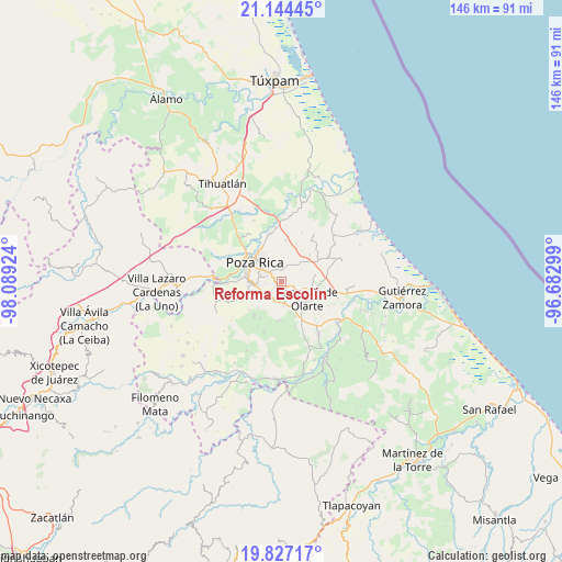
Reforma Escolín GPS coordinates[2]
20° 29' 13.992" North, 97° 23' 9.996" West
| Map corner | latitude | longitude |
|---|---|---|
| Upper-left | 21.14445°, | -98.08924° |
| Center: | 20.48722°, | -97.38611° |
| Lower-right: | 19.82717°, | -96.68299° |
| Map W x H: | 146.5×146.5 km | = 91×91mi |
| max Lat: | 32.7° ⇑32.5% North |
| Reforma Escolín: | 20.48722° |
| min Lat: | ⇓67.5% South 14.53588° |
| min Long | Reforma Escolí | max Long |
| -117.105° | -97.38611° | -86.73105° |
| W 70.7%⇐ | ⇒29.3% E |
Elevation
Elevation of Reforma Escolín is 193 m = 633 ft, and this is 1060.7 m = 3480 ft below average elevation for this country.
| Max E: |
3497 m = 11473 ft | 75.9% |
| Avg. | 1253.7 m = 4113 ft | |
| Reforma Escolín | 193 m = 633 ft | |
Min E: |
-1 m = -3 ft | 24.1% |
See also: Mexico elevation on elevation.city.
Geographical zone
Reforma Escolín is located in North Torrid zone (between Equator and Tropic of Cancer). Distance of this Northern Tropic circle is 328 km =203.8 mi to North.| Distance of | km | miles | from Reforma Escolín |
|---|---|---|---|
| North Pole | 7729.1 | 4802.6 | to North |
| Arctic Circle | 5123.2 | 3183.4 | to North |
| Tropic Cancer | 328 | 203.8 | to North |
| Equator | 2278 | 1415.5 | to South |


Nearby cities:
15 places around Reforma Escolín: (largest is in red/bold)
• Arroyo del Maíz Uno
6.3 km =3.9 mi,  331°
331°
• Coatzintla
8.6 km =5.3 mi,  269°
269°
• Congregación el Tajín
6.3 km =3.9 mi,  175°
175°
• Donato Márquez Azuara
4.8 km =3 mi,  28°
28°
• El Cabellal
7.1 km =4.4 mi,  21°
21°
• El Mollejon
6.6 km =4.1 mi,  336°
336°
• Escolín de Olarte
4.1 km =2.5 mi,  287°
287°
• La Concha
9.8 km =6.1 mi,  95°
95°
• La Grandeza
3.4 km =2.1 mi,  4°
4°
• La Laguna
7.7 km =4.8 mi,  230°
230°
• Papantla de Olarte
7.8 km =4.8 mi,  125°
125°
• Plan de los Mangos
9.6 km =6 mi, 32°
• Poza Rica de Hidalgo
9.2 km =5.7 mi,  303°
303°
• Tlahuanapa
8.6 km =5.3 mi,  164°
164°
• Troncones y Potrerillos
9 km =5.6 mi,  263°
263°
Sources, notices
• [Note1] Compared only with cities in Mexico existing in our database
• [Src1] Map data: © OpenStreetMap contributors (CC-BY-SA)
• [Src2] Other city data from geonames.org with taken over terms of usage.
• [Src3] Geographical zone / Annual Mean Temperature by Robert A. Rohde @ Wikipedia
