Necaxaltépetl geodata
Necaxaltépetl (Puebla) is a populated place; located in Mexico in America/Mexico_City (GMT-6) time zone. With population of 884 people, there are 9870 cities with bigger population in this country. Compared to other cities in Mexico, 62.1% of cities are located further ↓South; 63.7% of cities are located further ←West and 53.9% of cities have lower elevation than Necaxaltépetl. Note1


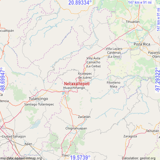
Necaxaltépetl GPS coordinates[2]
20° 14' 6.072" North, 97° 59' 46.824" West
| Map corner | latitude | longitude |
|---|---|---|
| Upper-left | 20.89334°, | -98.69947° |
| Center: | 20.23502°, | -97.99634° |
| Lower-right: | 19.5739°, | -97.29322° |
| Map W x H: | 146.7×146.7 km | = 91.2×91.2mi |
| max Lat: | 32.7° ⇑37.9% North |
| Necaxaltépetl: | 20.23502° |
| min Lat: | ⇓62.1% South 14.53588° |
| min Long | Necaxaltépetl | max Long |
| -117.105° | -97.99634° | -86.73105° |
| W 63.7%⇐ | ⇒36.3% E |
Elevation
Elevation of Necaxaltépetl is 1561 m = 5121 ft, and this is 307.3 m = 1008 ft above average elevation for this country.
| Max E: |
3497 m = 11473 ft | 46.1% |
| Necaxaltépetl | 1561 m 5121 ft | |
| Avg. | 1253.7 m = 4113 ft | |
Min E: |
-1 m = -3 ft | 53.9% |
See also: Mexico elevation on elevation.city.
Geographical zone
Necaxaltépetl is located in North Torrid zone (between Equator and Tropic of Cancer). Distance of this Northern Tropic circle is 356 km =221.2 mi to North.| Distance of | km | miles | from Necaxaltépetl |
|---|---|---|---|
| North Pole | 7757.1 | 4820 | to North |
| Arctic Circle | 5151.3 | 3200.9 | to North |
| Tropic Cancer | 356 | 221.2 | to North |
| Equator | 2249.9 | 1398 | to South |


Nearby cities:
15 places around Necaxaltépetl: (largest is in red/bold)
• Cuautlita
5 km =3.1 mi,  212°
212°
• Cuaxicala
3.2 km =2 mi,  277°
277°
• Duraznotla
3.6 km =2.2 mi,  33°
33°
• Lagunillas
5.5 km =3.4 mi,  103°
103°
• Las Colonias de Hidalgo
4.8 km =3 mi,  154°
154°
• Lomas Verdes
5.8 km =3.6 mi,  58°
58°
• Necaxa
3 km =1.9 mi, 213°
• Nuevo Necaxa
2.9 km =1.8 mi,  201°
201°
• Patoltecoya
4.7 km =2.9 mi,  230°
230°
• San Antonio Ocopetlatlán
5.4 km =3.4 mi,  75°
75°
• San Isidro
4 km =2.5 mi,  65°
65°
• Tenango de las Flores
3.4 km =2.1 mi,  165°
165°
• Tepetzintla de Galeana
5.7 km =3.5 mi,  330°
330°
• Tierra Negra
4.2 km =2.6 mi, 77°
• Tzahuinco
3.7 km =2.3 mi,  182°
182°
Sources, notices
• [Note1] Compared only with cities in Mexico existing in our database
• [Src1] Map data: © OpenStreetMap contributors (CC-BY-SA)
• [Src2] Other city data from geonames.org with taken over terms of usage.
• [Src3] Geographical zone / Annual Mean Temperature by Robert A. Rohde @ Wikipedia
