El Tepetate geodata
El Tepetate (Puebla) is a populated place; located in Mexico in America/Mexico_City (GMT-6) time zone. With population of 593 people, there are 14492 cities with bigger population in this country. Compared to other cities in Mexico, 66.2% of cities are located further ↓South; 66.3% of cities are located further ←West and 76.1% of cities have higher elevation than El Tepetate. Note1


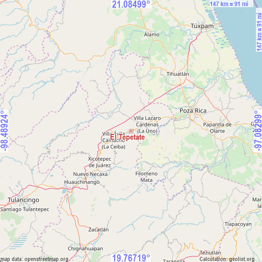
El Tepetate GPS coordinates[2]
20° 25' 39" North, 97° 47' 9.996" West
| Map corner | latitude | longitude |
|---|---|---|
| Upper-left | 21.08499°, | -98.48924° |
| Center: | 20.4275°, | -97.78611° |
| Lower-right: | 19.76719°, | -97.08299° |
| Map W x H: | 146.5×146.5 km | = 91×91mi |
| max Lat: | 32.7° ⇑33.8% North |
| El Tepetate: | 20.4275° |
| min Lat: | ⇓66.2% South 14.53588° |
| min Long | El Tepetate | max Long |
| -117.105° | -97.78611° | -86.73105° |
| W 66.3%⇐ | ⇒33.7% E |
Elevation
Elevation of El Tepetate is 184 m = 604 ft, and this is 1069.7 m = 3510 ft below average elevation for this country.
| Max E: |
3497 m = 11473 ft | 76.1% |
| Avg. | 1253.7 m = 4113 ft | |
| El Tepetate | 184 m = 604 ft | |
Min E: |
-1 m = -3 ft | 23.9% |
See also: Mexico elevation on elevation.city.
Geographical zone
El Tepetate is located in North Torrid zone (between Equator and Tropic of Cancer). Distance of this Northern Tropic circle is 334.6 km =207.9 mi to North.| Distance of | km | miles | from El Tepetate |
|---|---|---|---|
| North Pole | 7735.7 | 4806.7 | to North |
| Arctic Circle | 5129.8 | 3187.5 | to North |
| Tropic Cancer | 334.6 | 207.9 | to North |
| Equator | 2271.3 | 1411.3 | to South |


Nearby cities:
15 places around El Tepetate: (largest is in red/bold)
• Agua Linda
8.7 km =5.4 mi,  283°
283°
• Apapantilla
6.8 km =4.2 mi,  247°
247°
• Cerro Verde
10.3 km =6.4 mi,  159°
159°
• Coronel Tito Hernández
6.1 km =3.8 mi,  58°
58°
• Estrella Roja
11.1 km =6.9 mi,  83°
83°
• Gilberto Camacho
12 km =7.5 mi,  239°
239°
• La Libertad
10.2 km =6.3 mi,  74°
74°
• La Palma
4 km =2.5 mi,  118°
118°
• Nuevo Zoquiapan
2.8 km =1.7 mi, 66°
• Paso de Coyutla
8.9 km =5.5 mi, 83°
• Piedras Negras
3 km =1.9 mi, 59°
• Santa Rita
7.7 km =4.8 mi,  204°
204°
• Tenangulto
11.3 km =7 mi,  178°
178°
• Villa Avila Camacho
10.8 km =6.7 mi, 244°
• Villa Lázaro Cárdenas
9.7 km =6 mi, 66°
Sources, notices
• [Note1] Compared only with cities in Mexico existing in our database
• [Src1] Map data: © OpenStreetMap contributors (CC-BY-SA)
• [Src2] Other city data from geonames.org with taken over terms of usage.
• [Src3] Geographical zone / Annual Mean Temperature by Robert A. Rohde @ Wikipedia
