El Tecomate geodata
El Tecomate (Puebla) is a populated place; located in Mexico in America/Mexico_City (GMT-6) time zone. With population of 794 people, there are 10982 cities with bigger population in this country. Compared to other cities in Mexico, 72.9% of cities are located further ↓South; 66.5% of cities are located further ←West and 77.8% of cities have higher elevation than El Tecomate. Note1


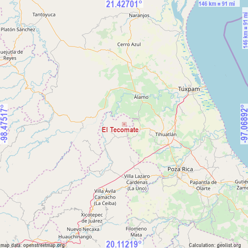
El Tecomate GPS coordinates[2]
20° 46' 15.708" North, 97° 46' 19.344" West
| Map corner | latitude | longitude |
|---|---|---|
| Upper-left | 21.42701°, | -98.47517° |
| Center: | 20.77103°, | -97.77204° |
| Lower-right: | 20.11219°, | -97.06892° |
| Map W x H: | 146.2×146.2 km | = 90.8×90.8mi |
| max Lat: | 32.7° ⇑27.1% North |
| El Tecomate: | 20.77103° |
| min Lat: | ⇓72.9% South 14.53588° |
| min Long | El Tecomate | max Long |
| -117.105° | -97.77204° | -86.73105° |
| W 66.5%⇐ | ⇒33.5% E |
Elevation
Elevation of El Tecomate is 135 m = 443 ft, and this is 1118.7 m = 3670 ft below average elevation for this country.
| Max E: |
3497 m = 11473 ft | 77.8% |
| Avg. | 1253.7 m = 4113 ft | |
| El Tecomate | 135 m = 443 ft | |
Min E: |
-1 m = -3 ft | 22.2% |
See also: Mexico elevation on elevation.city.
Geographical zone
El Tecomate is located in North Torrid zone (between Equator and Tropic of Cancer). Distance of this Northern Tropic circle is 296.4 km =184.2 mi to North.| Distance of | km | miles | from El Tecomate |
|---|---|---|---|
| North Pole | 7697.5 | 4783 | to North |
| Arctic Circle | 5091.7 | 3163.8 | to North |
| Tropic Cancer | 296.4 | 184.2 | to North |
| Equator | 2309.5 | 1435.1 | to South |


Nearby cities:
15 places around El Tecomate: (largest is in red/bold)
• Aquiles Serdán
11.8 km =7.3 mi,  49°
49°
• El Bejucal
12.4 km =7.7 mi,  72°
72°
• Emiliano Zapata
11.7 km =7.3 mi,  27°
27°
• La Defensa
12.7 km =7.9 mi,  153°
153°
• La Providencia
11.4 km =7.1 mi, 46°
• Las Balsas
7.6 km =4.7 mi,  189°
189°
• Mequetla
9.1 km =5.7 mi, 73°
• Metlaltoyuca
9.2 km =5.7 mi,  244°
244°
• Moctezuma
8.6 km =5.3 mi,  209°
209°
• Palma Real de Adentro
5.3 km =3.3 mi,  56°
56°
• Paso del Perro
8.5 km =5.3 mi,  346°
346°
• Rodríguez Clara
13.6 km =8.5 mi,  18°
18°
• Teayo
10.1 km =6.3 mi,  107°
107°
• Tincontlán
10.1 km =6.3 mi, 56°
• Venustiano Carranza
7.6 km =4.7 mi,  36°
36°
Sources, notices
• [Note1] Compared only with cities in Mexico existing in our database
• [Src1] Map data: © OpenStreetMap contributors (CC-BY-SA)
• [Src2] Other city data from geonames.org with taken over terms of usage.
• [Src3] Geographical zone / Annual Mean Temperature by Robert A. Rohde @ Wikipedia
