Matlahuacala geodata
Matlahuacala (Puebla) is a populated place; located in Mexico in America/Mexico_City (GMT-6) time zone. With population of 589 people, there are 14579 cities with bigger population in this country. Compared to other cities in Mexico, 55.9% of cities are located further ↓South; 63.2% of cities are located further ←West and 95% of cities have lower elevation than Matlahuacala. Note1


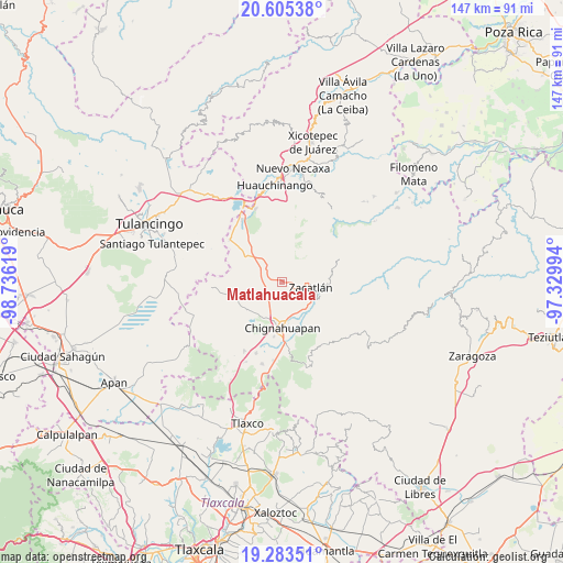
Matlahuacala GPS coordinates[2]
19° 56' 44.988" North, 98° 1' 59.016" West
| Map corner | latitude | longitude |
|---|---|---|
| Upper-left | 20.60538°, | -98.73619° |
| Center: | 19.94583°, | -98.03306° |
| Lower-right: | 19.28351°, | -97.32994° |
| Map W x H: | 147×147 km | = 91.3×91.3mi |
| max Lat: | 32.7° ⇑44.1% North |
| Matlahuacala: | 19.94583° |
| min Lat: | ⇓55.9% South 14.53588° |
| min Long | Matlahuacala | max Long |
| -117.105° | -98.03306° | -86.73105° |
| W 63.2%⇐ | ⇒36.8% E |
Elevation
Elevation of Matlahuacala is 2596 m = 8517 ft, and this is 1342.3 m = 4404 ft above average elevation for this country.
| Max E: |
3497 m = 11473 ft | 5% |
| Matlahuacala | 2596 m 8517 ft | |
| Avg. | 1253.7 m = 4113 ft | |
Min E: |
-1 m = -3 ft | 95% |
See also: Mexico elevation on elevation.city.
Geographical zone
Matlahuacala is located in North Torrid zone (between Equator and Tropic of Cancer). Distance of this Northern Tropic circle is 388.2 km =241.2 mi to North.| Distance of | km | miles | from Matlahuacala |
|---|---|---|---|
| North Pole | 7789.3 | 4840 | to North |
| Arctic Circle | 5183.4 | 3220.8 | to North |
| Tropic Cancer | 388.2 | 241.2 | to North |
| Equator | 2217.8 | 1378.1 | to South |


Nearby cities:
15 places around Matlahuacala: (largest is in red/bold)
• Atzingo (La Cumbre)
7.7 km =4.8 mi,  60°
60°
• Ayotla
2.9 km =1.8 mi,  194°
194°
• Jicolapa
6.6 km =4.1 mi,  70°
70°
• Las Lajas
7.2 km =4.5 mi,  324°
324°
• Las Lajas Primera Sección
9.2 km =5.7 mi, 319°
• Maquixtla
5.5 km =3.4 mi,  106°
106°
• Metepec
5.1 km =3.2 mi,  328°
328°
• Michac
10.6 km =6.6 mi, 190°
• Poxcuatzingo
5.9 km =3.7 mi,  76°
76°
• Pueblo Nuevo (Peñuelas)
8.2 km =5.1 mi,  277°
277°
• San Pedro Atmatla
7.9 km =4.9 mi,  119°
119°
• Tepoxcuautla
5.6 km =3.5 mi,  147°
147°
• Tlatempa
10.2 km =6.3 mi,  90°
90°
• Tomatlán
8.5 km =5.3 mi,  132°
132°
• Zacatlán
7.6 km =4.7 mi,  98°
98°
Sources, notices
• [Note1] Compared only with cities in Mexico existing in our database
• [Src1] Map data: © OpenStreetMap contributors (CC-BY-SA)
• [Src2] Other city data from geonames.org with taken over terms of usage.
• [Src3] Geographical zone / Annual Mean Temperature by Robert A. Rohde @ Wikipedia
