Tepexco geodata
Tepexco (Puebla) is a populated place; located in Mexico in America/Mexico_City (GMT-6) time zone. With population of 1,212 people, there are 7183 cities with bigger population in this country. Compared to other cities in Mexico, 57.6% of cities are located further ↓South; 64.1% of cities are located further ←West and 70.2% of cities have lower elevation than Tepexco. Note1


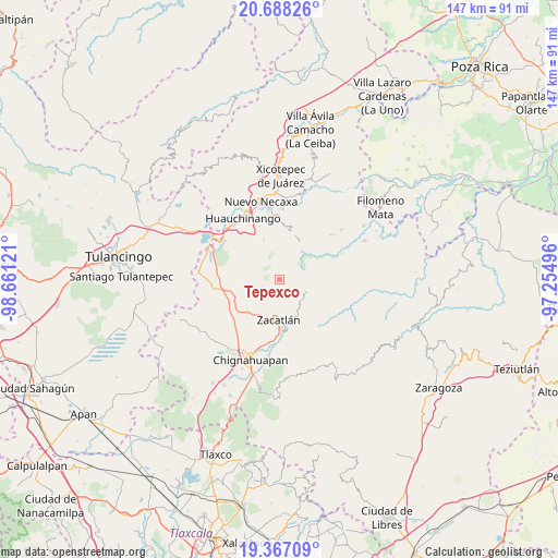
Tepexco GPS coordinates[2]
20° 1' 44.616" North, 97° 57' 29.088" West
| Map corner | latitude | longitude |
|---|---|---|
| Upper-left | 20.68826°, | -98.66121° |
| Center: | 20.02906°, | -97.95808° |
| Lower-right: | 19.36709°, | -97.25496° |
| Map W x H: | 146.9×146.9 km | = 91.3×91.3mi |
| max Lat: | 32.7° ⇑42.4% North |
| Tepexco: | 20.02906° |
| min Lat: | ⇓57.6% South 14.53588° |
| min Long | Tepexco | max Long |
| -117.105° | -97.95808° | -86.73105° |
| W 64.1%⇐ | ⇒35.9% E |
Elevation
Elevation of Tepexco is 1927 m = 6322 ft, and this is 673.3 m = 2209 ft above average elevation for this country.
| Max E: |
3497 m = 11473 ft | 29.8% |
| Tepexco | 1927 m 6322 ft | |
| Avg. | 1253.7 m = 4113 ft | |
Min E: |
-1 m = -3 ft | 70.2% |
See also: Mexico elevation on elevation.city.
Geographical zone
Tepexco is located in North Torrid zone (between Equator and Tropic of Cancer). Distance of this Northern Tropic circle is 378.9 km =235.4 mi to North.| Distance of | km | miles | from Tepexco |
|---|---|---|---|
| North Pole | 7780 | 4834.3 | to North |
| Arctic Circle | 5174.2 | 3215.1 | to North |
| Tropic Cancer | 378.9 | 235.4 | to North |
| Equator | 2227 | 1383.8 | to South |


Nearby cities:
15 places around Tepexco: (largest is in red/bold)
• Atzingo (La Cumbre)
5.6 km =3.5 mi,  191°
191°
• Chiconcuautla
7.6 km =4.7 mi,  15°
15°
• Cuetzalingo
5.9 km =3.7 mi,  39°
39°
• Jicolapa
7.2 km =4.5 mi, 192°
• Jilotzingo
5.8 km =3.6 mi,  86°
86°
• Palzoquitla
9.8 km =6.1 mi,  349°
349°
• Poxcuatzingo
8.1 km =5 mi,  195°
195°
• San Cristóbal Xochimilpa
6.7 km =4.2 mi,  51°
51°
• San Marcos Eloxochitlán
9 km =5.6 mi, 92°
• Tlatempa
9.7 km =6 mi,  165°
165°
• Tlaxco (Santiago Tlaxco)
3.2 km =2 mi, 351°
• Toxtla
4.3 km =2.7 mi,  14°
14°
• Xochicuautla
7.7 km =4.8 mi,  69°
69°
• Xoxonacatla
3 km =1.9 mi,  142°
142°
• Zempoala
7.7 km =4.8 mi,  326°
326°
Sources, notices
• [Note1] Compared only with cities in Mexico existing in our database
• [Src1] Map data: © OpenStreetMap contributors (CC-BY-SA)
• [Src2] Other city data from geonames.org with taken over terms of usage.
• [Src3] Geographical zone / Annual Mean Temperature by Robert A. Rohde @ Wikipedia
