Juxtlahuaca geodata
Juxtlahuaca (Guerrero) is a populated place; located in Mexico in America/Mexico_City (GMT-6) time zone. With population of 908 people, there are 9617 cities with bigger population in this country. Compared to other cities in Mexico, 83.9% of cities are located further ↑North; 51.8% of cities are located further →East and 62.3% of cities have higher elevation than Juxtlahuaca. Note1


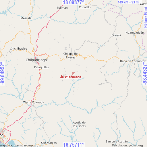
Juxtlahuaca GPS coordinates[2]
17° 25' 45.012" North, 99° 8' 47.004" West
| Map corner | latitude | longitude |
|---|---|---|
| Upper-left | 18.09877°, | -99.84952° |
| Center: | 17.42917°, | -99.14639° |
| Lower-right: | 16.75711°, | -98.44327° |
| Map W x H: | 149.2×149.2 km | = 92.7×92.7mi |
| max Lat: | 32.7° ⇑83.9% North |
| Juxtlahuaca: | 17.42917° |
| min Lat: | ⇓16.1% South 14.53588° |
| min Long | Juxtlahuaca | max Long |
| -117.105° | -99.14639° | -86.73105° |
| W 48.2%⇐ | ⇒51.8% E |
Elevation
Elevation of Juxtlahuaca is 865 m = 2838 ft, and this is 388.7 m = 1275 ft below average elevation for this country.
| Max E: |
3497 m = 11473 ft | 62.3% |
| Avg. | 1253.7 m = 4113 ft | |
| Juxtlahuaca | 865 m = 2838 ft | |
Min E: |
-1 m = -3 ft | 37.7% |
See also: Mexico elevation on elevation.city.
Geographical zone
Juxtlahuaca is located in North Torrid zone (between Equator and Tropic of Cancer). Distance of this Northern Tropic circle is 668 km =415.1 mi to North.| Distance of | km | miles | from Juxtlahuaca |
|---|---|---|---|
| North Pole | 8069.1 | 5013.9 | to North |
| Arctic Circle | 5463.2 | 3394.7 | to North |
| Tropic Cancer | 668 | 415.1 | to North |
| Equator | 1937.9 | 1204.2 | to South |


Nearby cities:
15 places around Juxtlahuaca: (largest is in red/bold)
• Acalco
8.8 km =5.5 mi,  345°
345°
• Atenxoxola
6.6 km =4.1 mi,  3°
3°
• Ayahualulco
8.8 km =5.5 mi,  334°
334°
• Colotlipa
2.9 km =1.8 mi,  229°
229°
• Coscamila
7.9 km =4.9 mi,  260°
260°
• El Jagüey
6.8 km =4.2 mi, 0°
• Jocutla
9.6 km =6 mi,  174°
174°
• Llano Grande
6.3 km =3.9 mi,  127°
127°
• Ostocapa
8.4 km =5.2 mi,  283°
283°
• San Ángel
6.2 km =3.9 mi,  340°
340°
• Santa Fe
5.7 km =3.5 mi,  251°
251°
• Tlalixtlahuacán
6.9 km =4.3 mi,  24°
24°
• Tlanicuilulco
6.2 km =3.9 mi,  135°
135°
• Xiloxuchicán
5 km =3.1 mi, 345°
• Zelocotitlán
4.7 km =2.9 mi,  65°
65°
Sources, notices
• [Note1] Compared only with cities in Mexico existing in our database
• [Src1] Map data: © OpenStreetMap contributors (CC-BY-SA)
• [Src2] Other city data from geonames.org with taken over terms of usage.
• [Src3] Geographical zone / Annual Mean Temperature by Robert A. Rohde @ Wikipedia
