San Pedro Tulixtlahuaca geodata
San Pedro Tulixtlahuaca (Oaxaca) is a populated place; located in Mexico in America/Mexico_City (GMT-6) time zone. With population of 1,717 people, there are 5057 cities with bigger population in this country. Compared to other cities in Mexico, 94.1% of cities are located further ↑North; 63.2% of cities are located further ←West and 70.1% of cities have higher elevation than San Pedro Tulixtlahuaca. Note1
Current local time in San Pedro Tulixtlahuaca:
10:07 AM, MondayDifference from your time zone: hours


San Pedro Tulixtlahuaca GPS coordinates[2]
16° 32' 22.992" North, 98° 2' 4.992" West
| Map corner | latitude | longitude |
|---|---|---|
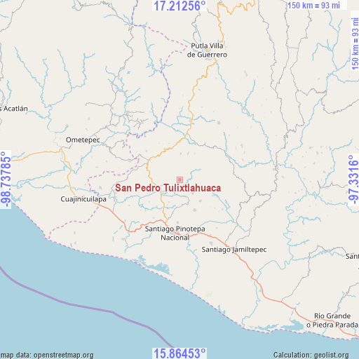
| Upper-left | 17.21256°, | -98.73785° |
| Center: | 16.53972°, | -98.03472° |
| Lower-right: | 15.86453°, | -97.3316° |
| Map W x H: | 149.9×149.9 km | = 93.1×93.1mi |
| max Lat: | 32.7° ⇑94.1% North |
| San Pedro Tulixtlahuaca: | 16.53972° |
| min Lat: | ⇓5.9% South 14.53588° |
| min Long | San Pedro Tulix | max Long |
| -117.105° | -98.03472° | -86.73105° |
| W 63.2%⇐ | ⇒36.8% E |
Elevation
Elevation of San Pedro Tulixtlahuaca is 410 m = 1345 ft, and this is 843.7 m = 2768 ft below average elevation for this country.
| Max E: |
3497 m = 11473 ft | 70.1% |
| Avg. | 1253.7 m = 4113 ft | |
| San Pedro Tulixtlahuaca | 410 m = 1345 ft | |
Min E: |
-1 m = -3 ft | 29.9% |
See also: Mexico elevation on elevation.city.
Geographical zone
San Pedro Tulixtlahuaca is located in North Torrid zone (between Equator and Tropic of Cancer). Distance of this Northern Tropic circle is 766.9 km =476.5 mi to North.| Distance of | km | miles | from San Pedro Tulixtlahuaca |
|---|---|---|---|
| North Pole | 8168 | 5075.4 | to North |
| Arctic Circle | 5562.1 | 3456.1 | to North |
| Tropic Cancer | 766.9 | 476.5 | to North |
| Equator | 1839 | 1142.7 | to South |


Nearby cities:
15 places around San Pedro Tulixtlahuaca: (largest is in red/bold)
• Camotinchan
9.8 km =6.1 mi,  282°
282°
• Chuparrosa
9 km =5.6 mi,  189°
189°
• Pie de la Cuesta
13.3 km =8.3 mi,  312°
312°
• San Antonio Tepetlapa
3.3 km =2.1 mi, 278°
• San José Yutatuyaa
10.1 km =6.3 mi, 185°
• San Juan Colorado
12.3 km =7.6 mi,  135°
135°
• San Juan Jicayán
7.5 km =4.7 mi,  161°
161°
• San Pedro Atoyac
7.6 km =4.7 mi, 136°
• San Pedro Jicayán
10 km =6.2 mi,  167°
167°
• San Sebastián Ixcapa
11.7 km =7.3 mi,  273°
273°
• Santa María Ipalapa
11.1 km =6.9 mi,  1°
1°
• Santiago Jicayán
7.3 km =4.5 mi, 158°
• Sayultepec
11.9 km =7.4 mi,  301°
301°
• Yutandayoo
10.2 km =6.3 mi,  206°
206°
• Zocoteaca de León
11.5 km =7.1 mi,  17°
17°
Sources, notices
• [Note1] Compared only with cities in Mexico existing in our database
• [Src1] Map data: © OpenStreetMap contributors (CC-BY-SA)
• [Src2] Other city data from geonames.org with taken over terms of usage.
• [Src3] Geographical zone / Annual Mean Temperature by Robert A. Rohde @ Wikipedia
