San Pedro Atoyac geodata
San Pedro Atoyac (Oaxaca) is a seat of a second-order administrative division; located in Mexico in America/Mexico_City (GMT-6) time zone. With population of 2,527 people, there are 3508 cities with bigger population in this country. Compared to other cities in Mexico, 94.4% of cities are located further ↑North; 63.8% of cities are located further ←West and 74.3% of cities have higher elevation than San Pedro Atoyac. Note1


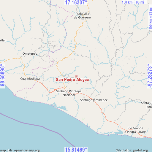
San Pedro Atoyac GPS coordinates[2]
16° 29' 24.18" North, 97° 59' 9.06" West
| Map corner | latitude | longitude |
|---|---|---|
| Upper-left | 17.16307°, | -98.68898° |
| Center: | 16.49005°, | -97.98585° |
| Lower-right: | 15.81469°, | -97.28273° |
| Map W x H: | 149.9×149.9 km | = 93.1×93.1mi |
| max Lat: | 32.7° ⇑94.4% North |
| San Pedro Atoyac: | 16.49005° |
| min Lat: | ⇓5.6% South 14.53588° |
| min Long | San Pedro Atoya | max Long |
| -117.105° | -97.98585° | -86.73105° |
| W 63.8%⇐ | ⇒36.2% E |
Elevation
Elevation of San Pedro Atoyac is 243 m = 797 ft, and this is 1010.7 m = 3316 ft below average elevation for this country.
| Max E: |
3497 m = 11473 ft | 74.3% |
| Avg. | 1253.7 m = 4113 ft | |
| San Pedro Atoyac | 243 m = 797 ft | |
Min E: |
-1 m = -3 ft | 25.7% |
See also: Mexico elevation on elevation.city.
Geographical zone
San Pedro Atoyac is located in North Torrid zone (between Equator and Tropic of Cancer). Distance of this Northern Tropic circle is 772.4 km =479.9 mi to North.| Distance of | km | miles | from San Pedro Atoyac |
|---|---|---|---|
| North Pole | 8173.5 | 5078.8 | to North |
| Arctic Circle | 5567.7 | 3459.6 | to North |
| Tropic Cancer | 772.4 | 479.9 | to North |
| Equator | 1833.5 | 1139.3 | to South |


Nearby cities:
15 places around San Pedro Atoyac: (largest is in red/bold)
• Chuparrosa
7.5 km =4.7 mi,  243°
243°
• Nuevo Progreso
10.4 km =6.5 mi,  70°
70°
• Pinotepa de Don Luis
7.1 km =4.4 mi,  172°
172°
• San Antonio Tepetlapa
10.4 km =6.5 mi,  305°
305°
• San José Yutatuyaa
7.6 km =4.7 mi,  233°
233°
• San Juan Colorado
4.7 km =2.9 mi,  134°
134°
• San Juan Jicayán
3.3 km =2.1 mi, 240°
• San Juan Yosocani
11 km =6.8 mi,  124°
124°
• San Miguel Tlacamama
11.7 km =7.3 mi,  224°
224°
• San Pedro Jicayán
5.2 km =3.2 mi, 215°
• San Pedro Tulixtlahuaca
7.6 km =4.7 mi,  316°
316°
• Santa María Nutío
8.7 km =5.4 mi,  93°
93°
• Santiago Jicayán
2.9 km =1.8 mi, 244°
• Siniyuvi
6.4 km =4 mi,  103°
103°
• Yutandayoo
10.4 km =6.5 mi,  249°
249°
Sources, notices
• [Note1] Compared only with cities in Mexico existing in our database
• [Src1] Map data: © OpenStreetMap contributors (CC-BY-SA)
• [Src2] Other city data from geonames.org with taken over terms of usage.
• [Src3] Geographical zone / Annual Mean Temperature by Robert A. Rohde @ Wikipedia
